Difference between revisions of "2021-12-17 62 29"
| Line 19: | Line 19: | ||
We discussed a possible [[Frozen Geohash|Frozen]] [[Hobbit achievement]] on Discord. While it will be theoretically possible (the temperature will be about −5 °C), I am afraid of how my feet will cope. I could probably run to the hashpoint barefoot and back home, but stopping twice to eat might be too much to take. I will consider it in the morning. | We discussed a possible [[Frozen Geohash|Frozen]] [[Hobbit achievement]] on Discord. While it will be theoretically possible (the temperature will be about −5 °C), I am afraid of how my feet will cope. I could probably run to the hashpoint barefoot and back home, but stopping twice to eat might be too much to take. I will consider it in the morning. | ||
| − | == Expedition == | + | == Expedition #1 == |
| − | + | I left for the first visit just before midnight. I got outside, and after a couple of minutes of jogging I was at the hashpoint. For some reason, I had a surprising amount of trouble finding it with the GPS receiver: the measured location jumped all over the place, and the GPS uncertainty was high, while it usually stabilises to 2–4 m. Regardless, I was able to get to a place where I could take photos for proof. | |
| + | |||
| + | I will be back later today. I will need taller rubber boots since there was too much snow for my "winter boots", about 40 cm. The temperature was 0 °C, and it is expected to get down to −5 °C during the day. There was sufficient light from the street lights that I could see perfectly, but I will need to wait for the morning to get enough light for the camera. | ||
== Photos == | == Photos == | ||
| − | |||
| − | |||
| − | |||
<gallery perrow="5"> | <gallery perrow="5"> | ||
| + | Image:2021-12-17_62_29_01-gpsr1.jpg | GPS receiver at the hashpoint at midnight. The image is blurry, but is shows the location N 62.62078°, E 29.81023°, 3 m to the geohash, with a GPS uncertainty of 6 m. | ||
| + | Image:2021-12-17_62_29_02-gpsr2.jpg | Legible proof of location. | ||
| + | Image:2021-12-17_62_29_03-gpsr3.jpg | Proof of date and time. | ||
| + | Image:2021-12-17_62_29_04-selfie1.jpg | Selfie at the hashpoint at midnight. | ||
</gallery> | </gallery> | ||
== Achievements == | == Achievements == | ||
{{#vardefine:ribbonwidth|800px}} | {{#vardefine:ribbonwidth|800px}} | ||
| − | |||
| − | |||
| − | |||
| − | |||
| − | |||
| − | |||
| − | |||
| − | |||
| − | |||
| − | |||
| − | |||
| − | |||
| − | + | {{land geohash | latitude = 62 | longitude = 29 | date = 2021-12-17 | name = Kripakko}} | |
| + | {{midnight geohash | latitude = 62 | longitude = 29 | date = 2021-12-17 | name = Kripakko}} | ||
| − | |||
[[Category:Expeditions]] | [[Category:Expeditions]] | ||
| − | |||
[[Category:Expeditions with photos]] | [[Category:Expeditions with photos]] | ||
| − | |||
| − | |||
| − | |||
| − | |||
| − | |||
[[Category:Coordinates reached]] | [[Category:Coordinates reached]] | ||
| − | |||
| − | |||
| − | |||
| − | |||
| − | |||
| − | |||
| − | |||
| − | |||
| − | |||
| − | |||
| − | |||
| − | |||
| − | |||
| − | |||
| − | |||
| − | |||
| − | |||
| − | |||
Revision as of 23:02, 16 December 2021
| Fri 17 Dec 2021 in 62,29: 62.6207624, 29.8101840 geohashing.info google osm bing/os kml crox |
Location
In a forest near Jukolankatu road in Joensuu. About 400 metres from my home.
Participants
Plans
This point is very close to my home and on public property. Now I have good chances of scoring several achievements, perhaps on several expeditions:
- Reconnaissance mission at midnight. As I write this, it is less than two hours to midnight.
- After about half past eight, there is enough daylight so I can see without artificial light. I can try to build a snowman and do other silly things if I feel like it.
- Sunrise at 9:28. Yes, I am not far from the artic circle, and the winter solstice will occur in a few days.
We discussed a possible Frozen Hobbit achievement on Discord. While it will be theoretically possible (the temperature will be about −5 °C), I am afraid of how my feet will cope. I could probably run to the hashpoint barefoot and back home, but stopping twice to eat might be too much to take. I will consider it in the morning.
Expedition #1
I left for the first visit just before midnight. I got outside, and after a couple of minutes of jogging I was at the hashpoint. For some reason, I had a surprising amount of trouble finding it with the GPS receiver: the measured location jumped all over the place, and the GPS uncertainty was high, while it usually stabilises to 2–4 m. Regardless, I was able to get to a place where I could take photos for proof.
I will be back later today. I will need taller rubber boots since there was too much snow for my "winter boots", about 40 cm. The temperature was 0 °C, and it is expected to get down to −5 °C during the day. There was sufficient light from the street lights that I could see perfectly, but I will need to wait for the morning to get enough light for the camera.
Photos
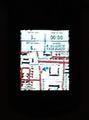
GPS receiver at the hashpoint at midnight. The image is blurry, but is shows the location N 62.62078°, E 29.81023°, 3 m to the geohash, with a GPS uncertainty of 6 m.
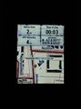
Legible proof of location.
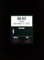
Proof of date and time.
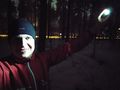
Selfie at the hashpoint at midnight.


Achievements
Kripakko earned the Land geohash achievement
|
Kripakko earned the Midnight Geohash achievement
|