Difference between revisions of "2022-03-15 54 13"
(→Location) |
|||
| Line 1: | Line 1: | ||
| − | + | {{meetup graticule | |
| − | |||
| − | |||
| − | |||
| − | |||
| − | |||
| − | |||
| − | |||
| − | |||
| lat=54 | | lat=54 | ||
| lon=13 | | lon=13 | ||
| date=2022-03-15 | | date=2022-03-15 | ||
| − | }} | + | }} |
__NOTOC__ | __NOTOC__ | ||
== Location == | == Location == | ||
| Line 17: | Line 9: | ||
== Participants == | == Participants == | ||
| − | + | * [[User:42LoCo42|42LoCo42]] | |
| − | -- | + | * [[User:Ercanar-senpai|Ercanar-senpai]] |
== Plans == | == Plans == | ||
| − | + | Take the train from [[User:Ercanar-senpai|Ercanar's]] home to Sassnitz-Lancken, then walk to the hash. | |
| + | Go to Sagard, then ride home. Boring, but what did you expect for our first hash? | ||
== Expedition == | == Expedition == | ||
| − | + | As the hash required only a small amount of physical effort, we equipped ourselves with just one backpack | |
| + | containing water and some fruits. | ||
| − | + | During the train ride to Lancken, we were not discovered by a conductor and thus could save some cash | |
| − | + | (tickets would have to be bought on the train, as there is no vending machine at our local train stop). | |
| + | |||
| + | From Lancken, it was only a 4 km walk to the hash, which was only slightly complicated by the hilly terrain. | ||
| + | To reach the hash, we followed nearby dirt paths until we got to the closest point at ~200 m distance. | ||
| + | From here, we just crossed the field, utilizing existing tracks left by tractors. | ||
| + | |||
| + | After some photos, we returned to the path and visited the old chalk quarries, one of which seems to have been converted | ||
| + | to a bike racing track. We also found large, dry thistles and got very excited about the sounds their dry needles make. | ||
| + | This contributed to us inadvertently missing the next train home. | ||
| + | |||
| + | On our way to the train station in Sagard, we found a black cat. It was immediately friendly | ||
| + | and lead us to an abandoned building and the imposing "Paltrockmühle" (Paltrok mill). | ||
| + | The cat was obviously a quest giver, but we could sadly not complete its demands since we didn't feel like missing another train. | ||
== Photos == | == Photos == | ||
| − | |||
| − | |||
| − | |||
<gallery perrow="5"> | <gallery perrow="5"> | ||
| + | File:20220315_153831.jpg | 42LoCo42 at the hash | ||
| + | File:20220315_153851.jpg | The surrounding area (just more fields) | ||
| + | File:Screenshot_20220315-153400_Maps.jpg | Approach to the hash | ||
| + | File:Screenshot_20220315-153816_Geohash_Droid.jpg | We are there! | ||
| + | File:20220315_161355.jpg | The cat with a quest | ||
| + | File:20220315_161405.jpg | Obvious boss room | ||
| + | File:20220315_161407.jpg | Cat at boss room | ||
| + | File:20220315_170408.jpg | Cat risking one of their 9 lives | ||
| + | File:20220315_165811.jpg | The Paltrockmühle, one of the few left in Germany | ||
</gallery> | </gallery> | ||
== Achievements == | == Achievements == | ||
{{#vardefine:ribbonwidth|800px}} | {{#vardefine:ribbonwidth|800px}} | ||
| − | + | {{land geohash | latitude = 54 | longitude = 13 | date = 2022-03-15 | name = 42LoCo42 and Ercanar-senpai}} | |
| − | + | {{Hashcat | latitude = 54 | longitude = 13 | date = 2022-03-15 | name = 42LoCo42 and Ercanar-senpai}} | |
| − | + | {{Two to the N achievement | count = 0 | latitude = 54 | longitude = 13 | date = 2022-03-15 | name = 42LoCo42 and Ercanar-senpai}} | |
| − | |||
| − | |||
| − | |||
| − | |||
| − | |||
| − | |||
| − | |||
| − | |||
| − | |||
| − | |||
| − | |||
| − | |||
[[Category:Expeditions]] | [[Category:Expeditions]] | ||
| − | |||
[[Category:Expeditions with photos]] | [[Category:Expeditions with photos]] | ||
| − | |||
[[Category:Expedition without GPS]] | [[Category:Expedition without GPS]] | ||
| − | |||
| − | |||
| − | |||
[[Category:Coordinates reached]] | [[Category:Coordinates reached]] | ||
| − | |||
| − | |||
| − | |||
| − | |||
| − | |||
| − | |||
| − | |||
| − | |||
| − | |||
| − | |||
| − | |||
| − | |||
| − | |||
| − | |||
| − | |||
| − | |||
| − | |||
| − | |||
Revision as of 22:29, 15 March 2022
| Tue 15 Mar 2022 in 54,13: 54.5115605, 13.5678319 geohashing.info google osm bing/os kml crox |
Location
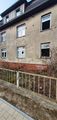
A field on hilly terrain, near some burial mounds and two abandoned chalk quarries
Participants
Plans
Take the train from Ercanar's home to Sassnitz-Lancken, then walk to the hash. Go to Sagard, then ride home. Boring, but what did you expect for our first hash?
Expedition
As the hash required only a small amount of physical effort, we equipped ourselves with just one backpack containing water and some fruits.
During the train ride to Lancken, we were not discovered by a conductor and thus could save some cash (tickets would have to be bought on the train, as there is no vending machine at our local train stop).
From Lancken, it was only a 4 km walk to the hash, which was only slightly complicated by the hilly terrain. To reach the hash, we followed nearby dirt paths until we got to the closest point at ~200 m distance. From here, we just crossed the field, utilizing existing tracks left by tractors.
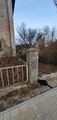
After some photos, we returned to the path and visited the old chalk quarries, one of which seems to have been converted to a bike racing track. We also found large, dry thistles and got very excited about the sounds their dry needles make. This contributed to us inadvertently missing the next train home.
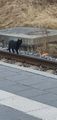
On our way to the train station in Sagard, we found a black cat. It was immediately friendly and lead us to an abandoned building and the imposing "Paltrockmühle" (Paltrok mill). The cat was obviously a quest giver, but we could sadly not complete its demands since we didn't feel like missing another train.
Photos
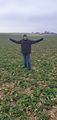
42LoCo42 at the hash
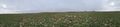
The surrounding area (just more fields)
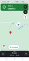
Approach to the hash
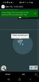
We are there!
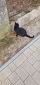
The cat with a quest
Obvious boss room
Cat at boss room
Cat risking one of their 9 lives
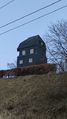
The Paltrockmühle, one of the few left in Germany


Achievements
42LoCo42 and Ercanar-senpai earned the Land geohash achievement
|
42LoCo42 and Ercanar-senpai earned the Hashcat achievement
|
42LoCo42 and Ercanar-senpai earned the Two to the N achievement
|