Difference between revisions of "2022-08-28 44 -122"
Michael5000 (talk | contribs) (→Participants) |
Michael5000 (talk | contribs) |
||
| Line 20: | Line 20: | ||
*[[User:Michael5000|Michael5000]] | *[[User:Michael5000|Michael5000]] | ||
| − | == | + | == Expedition == |
| − | |||
| − | + | I did a lot of work on Saturday to free myself up for another try at the Springfield graticule after [[2022-08-20 44 -122|last weekend's disappointment]]. Sunday morning I drove down to the little village of Scio, with the hope of running 6 miles, a little further than I've managed the last few months. I immediately crossed one of their attractive covered bridges, then headed east on Highway 226 to Richardson Gap Road. Another attractive covered bridge was closed for construction there, but I was able to cross the creek on a temporary construction structure, and then continue north a few hundred meters to... an epic hill. Although the run was going well, I had to walk this stretch. Once the slope evened out, I turned my tracker back on and turned west onto Ridge Road, then south onto Brock Drive, which took me right to the hashpoint. After the usual celebrations, I ran the rest of the way back to Scio, ending at 6.12 miles, which I was happy with. | |
| − | + | ||
| + | Back at the car, I changed my shirt and got on my bike, which I rode on a different route, but went back over the hashpoint again just for fun. | ||
| − | + | And then I drove home! | |
| − | |||
== Photos == | == Photos == | ||
| − | + | ||
| − | |||
| − | |||
<gallery perrow="5"> | <gallery perrow="5"> | ||
| + | File:2022-08-28 44 -122 e.jpg|Scio! | ||
| + | File:2022-08-28 44 -122 a.jpg|The hills-and-fields landscape around the hashpoint. | ||
| + | File:2022-08-28 44 -122 b.jpg|Brock Road from the hashpoint | ||
| + | File:2022-08-28 44 -122 c.jpg|Brock Road the other way, from the hashpoint | ||
| + | File:2022-08-28 44 -122 d.jpg|Michael5000, at the hashpoint. | ||
</gallery> | </gallery> | ||
== Achievements == | == Achievements == | ||
{{#vardefine:ribbonwidth|100%}} | {{#vardefine:ribbonwidth|100%}} | ||
| − | |||
__NOTOC__ | __NOTOC__ | ||
| − | |||
| − | |||
| − | |||
| − | |||
| − | |||
| − | |||
| − | |||
| − | |||
| − | |||
| − | |||
| − | |||
| − | |||
| − | |||
| − | |||
[[Category:Expeditions]] | [[Category:Expeditions]] | ||
| − | |||
[[Category:Expeditions with photos]] | [[Category:Expeditions with photos]] | ||
| − | |||
| − | |||
| − | |||
| − | |||
| − | |||
[[Category:Coordinates reached]] | [[Category:Coordinates reached]] | ||
| − | |||
| − | |||
| − | |||
| − | |||
| − | |||
| − | |||
| − | |||
| − | |||
| − | |||
| − | |||
| − | |||
| − | |||
| − | |||
| − | |||
| − | |||
| − | |||
| − | |||
| − | |||
Revision as of 03:25, 29 August 2022
| Sun 28 Aug 2022 in 44,-122: 44.7196101, -122.8334665 geohashing.info google osm bing/os kml crox |
Location
On Brock Drive, northeast of Scio.
Participants
Expedition
I did a lot of work on Saturday to free myself up for another try at the Springfield graticule after last weekend's disappointment. Sunday morning I drove down to the little village of Scio, with the hope of running 6 miles, a little further than I've managed the last few months. I immediately crossed one of their attractive covered bridges, then headed east on Highway 226 to Richardson Gap Road. Another attractive covered bridge was closed for construction there, but I was able to cross the creek on a temporary construction structure, and then continue north a few hundred meters to... an epic hill. Although the run was going well, I had to walk this stretch. Once the slope evened out, I turned my tracker back on and turned west onto Ridge Road, then south onto Brock Drive, which took me right to the hashpoint. After the usual celebrations, I ran the rest of the way back to Scio, ending at 6.12 miles, which I was happy with.
Back at the car, I changed my shirt and got on my bike, which I rode on a different route, but went back over the hashpoint again just for fun.
And then I drove home!
Photos
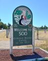
Scio!
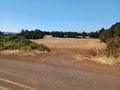
The hills-and-fields landscape around the hashpoint.
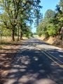
Brock Road from the hashpoint
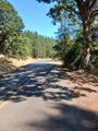
Brock Road the other way, from the hashpoint
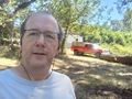
Michael5000, at the hashpoint.


