|
|
| Line 58: |
Line 58: |
| | [[Category:Coordinates reached]] | | [[Category:Coordinates reached]] |
| | {{location|NO|11}} | | {{location|NO|11}} |
| − |
| |
| | __NOTOC__ | | __NOTOC__ |
| − | <!-- =============== USEFUL CATEGORIES FOLLOW ================
| |
| − | Delete the next line ONLY if you have chosen the appropriate categories below. If you are unsure, don't worry. People will read your report and help you with the classification. -->
| |
| − | [[Category:New report]]
| |
| − |
| |
| − | <!-- ==REQUEST FOR TWITTER BOT== Please leave either the New report or the Expedition planning category in as long as you work on it. This helps the twitter bot a lot with announcing the right outcome at the right moment. -->
| |
| − |
| |
| − | <!-- Potential categories. Please include all the ones appropriate to your expedition -->
| |
| − | <!-- If this is a planning page:
| |
| − | [[Category:Expedition planning]]
| |
| − | -->
| |
| − |
| |
| − | <!-- If all those plans are never acted upon, change [[Category:Expedition planning]] to [[Category:Not reached - Did not attempt]]. -->
| |
| − |
| |
| − | <!-- An actual expedition:
| |
| − | [[Category:Expeditions]]
| |
| − | -- and one or more of --
| |
| − | [[Category:Expeditions with photos]]
| |
| − | [[Category:Expeditions with videos]]
| |
| − | [[Category:Expedition without GPS]]
| |
| − | -->
| |
| − |
| |
| − | <!-- if you reached your coords:
| |
| − | [[Category:Coordinates reached]]
| |
| − |
| |
| − |
| |
| − | --><!-- or if you failed :(
| |
| − | [[Category:Coordinates not reached]]
| |
| − | -- and a reason --
| |
| − | When there is a natural obstacle between you and the target:
| |
| − | [[Category:Not reached - Mother Nature]]
| |
| − |
| |
| − | When there is a man-made obstacle between you and the target:
| |
| − | [[Category:Not reached - No public access]]
| |
| − |
| |
| − | When you failed get your GPS, car, bike or such to work:
| |
| − | [[Category:Not reached - Technology]]
| |
| − |
| |
| − | When you went to an alternate location instead of the actual geohash:
| |
| − | [[Category:Not reached - Attended alternate location]]
| |
| − |
| |
| − | (Don't forget to delete this final close comment marker) -->
| |
Location
Kyllingstad, Gjesdal, Norway
Participants
Plans
Expedition
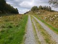
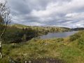
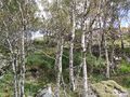
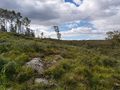
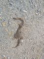
Today's hash trip was like several other trips, very nice. The hash was easy to find so the trip went quite quickly. The only negative was that I found a dead viper. I find vipers to be very fascinating animals, so it is sad to find one that has been hit by a tractor.
Tracklog
Photos
Achievements