Difference between revisions of "2023-01-06 59 5"
From Geohashing
(→Expedition) |
(+Virgin) |
||
| Line 49: | Line 49: | ||
{{#vardefine:ribbonwidth|100%}} | {{#vardefine:ribbonwidth|100%}} | ||
<!-- Add any achievement ribbons you earned below, or remove this section --> | <!-- Add any achievement ribbons you earned below, or remove this section --> | ||
| − | + | {{Virgin graticule | |
| + | | latitude = 59 | ||
| + | | longitude = 5 | ||
| + | | date = 2023-01-06 | ||
| + | | name = Pica42 | ||
| + | | image = 20230106 114537.jpg | ||
| + | }} | ||
{{land geohash |name=[[User:Pica42|Pica42]] |date=2023-01-06 |latitude=59 |longitude=5 }} | {{land geohash |name=[[User:Pica42|Pica42]] |date=2023-01-06 |latitude=59 |longitude=5 }} | ||
Revision as of 18:53, 9 February 2023
| Fri 6 Jan 2023 in 59,5: 59.0338205, 5.7007135 geohashing.info google osm bing/os kml crox |

Location
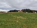
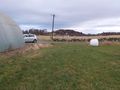
On a farm on the island of Åmøy in Stavanger, Norway.
Participants
Plans
Expedition
Today's trip was in changing weather, a few minutes in fine weather, then a few minutes with rain. This is how it lasted the whole trip. After a car trip of about 44 km, it was only about 30 meters to walk to the hash.
Tracklog
Photos

Åmøy @59.0339,5.7007

Åmøy
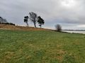
View to the south.
View to the southeast.
View to the north.


Achievements
Pica42 earned the Land geohash achievement
|