Difference between revisions of "2023-07-16 45 -122"
Michael5000 (talk | contribs) (→Expedition) |
Michael5000 (talk | contribs) (→Photos) |
||
| Line 35: | Line 35: | ||
== Photos == | == Photos == | ||
| − | + | ||
| − | |||
| − | |||
<gallery perrow="5"> | <gallery perrow="5"> | ||
| + | File:2023-07-16 45 -122 a.jpg|View from the hashpoint | ||
| + | File:2023-07-16 45 -122 b.jpg|Me, looking dumb at the hashpoint | ||
| + | File:2023-07-16 45 -122 d.jpg|Evidence | ||
| + | File:2023-07-16 45 -122 c.jpg|View north up the Willamette River, from later in the ride | ||
</gallery> | </gallery> | ||
Revision as of 23:24, 16 July 2023
| Sun 16 Jul 2023 in 45,-122: 45.5486252, -122.6723415 geohashing.info google osm bing/os kml crox |
Location
On North Kerby Avenue, near Fremont.
Participants
Plans
Expedition
I don't usually forget that I'm geohashing when I'm geohashing, but as I peddled past the Lloyd district and up towards Mississippi-Albina I found myself thinking "well, this is a pleasant bike ride, but now where am I going, again?" Well, today's hashpoint was only a few hundred meters from where I was born, so perhaps I was bicycling back towards my birthplace purely on instinct, like a salmon navigating by smell back to the pool where he was hatched. But, well -- probably not.
The hashpoint is on an ordinary residential street. I didn't see any evidence of geohashers before me, and I chided myself for neglecting to bring chalk in case someone came after me.
I continued the bicycle ride to pick up a book at Powell's, and then came home. Total round trip: 11 miles.
Tracklog
Photos
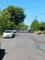
View from the hashpoint
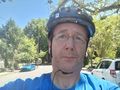
Me, looking dumb at the hashpoint
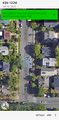
Evidence
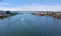
View north up the Willamette River, from later in the ride


Achievements