Difference between revisions of "2023-09-30 44 -122"
Michael5000 (talk | contribs) |
Michael5000 (talk | contribs) (→Achievements) |
||
| Line 42: | Line 42: | ||
__NOTOC__ | __NOTOC__ | ||
| − | |||
| − | |||
| − | |||
| − | |||
| − | |||
| − | |||
| − | |||
| − | |||
| − | |||
| − | |||
| − | |||
| − | |||
| − | |||
| − | |||
[[Category:Expeditions]] | [[Category:Expeditions]] | ||
| − | |||
[[Category:Expeditions with photos]] | [[Category:Expeditions with photos]] | ||
| − | |||
| − | |||
| − | |||
| − | |||
| − | |||
[[Category:Coordinates reached]] | [[Category:Coordinates reached]] | ||
| − | |||
| − | |||
| − | |||
| − | |||
| − | |||
| − | |||
| − | |||
| − | |||
| − | |||
| − | |||
| − | |||
| − | |||
| − | |||
| − | |||
| − | |||
| − | |||
| − | |||
| − | |||
Revision as of 19:58, 1 October 2023
| Sat 30 Sep 2023 in 44,-122: 44.8278284, -122.7885487 geohashing.info google osm bing/os kml crox |
Location
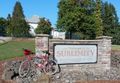
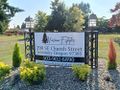
In an assisted living development in Sublimity.
Participants
Expedition
It was a sunny Autumn day, and why not? I drove down to the Marion County town of Aumsville, then rode my bike west to Turner, south and then east to Stayton, and then a very short hop north to Sublimity, the small town where the hashpoint was.
From looking at online imagery, I knew what I was looking for -- the hashpoint was at or near a little utility enclosure at the corner of a memory care facility. As I rode into the complex, I saw the place I was looking for immediately, rode right up to it, and got out my phone to make sure I was exactly in the right place. But, oddly, I wasn't in the right place. It showed the hashpoint as being over to the northeast, which was weird because there weren't any buildings to the northeast of the size I was looking for. Confused, I rode around the streets and parking lots for a while, trying to figure out what was up.
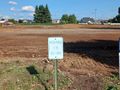
What was up was, the buildings shown online have recently been torn down to make way for a smoothly graded construction pad. At the edge of the extensive cleared space, the hashpoint was clearly and cheerfully marked with orange pylons -- but I'm 99.9% sure that this was random construction debris, and not landmarks left by earlier geohashers.
And then of course I rode the bicycle back to Aumsville, drove the vehicle back to Portland, and here I am taking care of the paperwork!
Photos
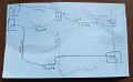
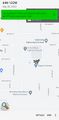
The expedition plan.
Fippe's is not the only bicycle!
Entering the hashpoint campus.
Fortunately, I am a doctor.
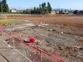
The pylons mark the spot!
Yay.


