Difference between revisions of "2023-09-30 44 -122"
m (Location) |
m (subst-ing) |
||
| Line 8: | Line 8: | ||
And DON'T FORGET to add your expedition and the best photo you took to the gallery on the Main Page! We'd love to read your report, but that means we first have to discover it! :) | And DON'T FORGET to add your expedition and the best photo you took to the gallery on the Main Page! We'd love to read your report, but that means we first have to discover it! :) | ||
-->{{meetup graticule | -->{{meetup graticule | ||
| − | | lat= | + | | lat=44 |
| − | | lon= | + | | lon=-122 |
| − | | date= | + | | date=2023-09-30 |
}}<!-- edit as necessary --> | }}<!-- edit as necessary --> | ||
== Location == | == Location == | ||
Latest revision as of 21:07, 24 May 2024
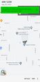
| Sat 30 Sep 2023 in 44,-122: 44.8278284, -122.7885487 geohashing.info google osm bing/os kml crox |
Location
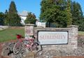
In an assisted living development in Sublimity.
Participants
Expedition
It was a sunny Autumn day, and why not? I drove down to the Marion County town of Aumsville, then rode my bike west to Turner, south and then east to Stayton, and then a very short hop north to Sublimity, the small town where the hashpoint was.
From looking at online imagery, I knew what I was looking for -- the hashpoint was at or near a little utility enclosure at the corner of a memory care facility. As I rode into the complex, I saw the place I was looking for immediately, rode right up to it, and got out my phone to make sure I was exactly in the right place. But, oddly, I wasn't in the right place. It showed the hashpoint as being over to the northeast, which was weird because there weren't any buildings to the northeast of the size I was looking for. Confused, I rode around the streets and parking lots for a while, trying to figure out what was up.
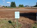
What was up was, the buildings shown online have recently been torn down to make way for a smoothly graded construction pad. At the edge of the extensive cleared space, the hashpoint was clearly and cheerfully marked with orange pylons -- but I'm 99.9% sure that this was random construction debris, and not landmarks left by earlier geohashers.
And then of course I rode the bicycle back to Aumsville, drove the vehicle back to Portland, and here I am taking care of the paperwork!
Photos
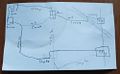
The expedition plan.
Fippe's is not the only bicycle!
Entering the hashpoint campus.
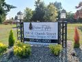
Fortunately, I am a doctor.
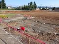
The pylons mark the spot!
Yay.


