Difference between revisions of "2024-01-27 50 14"
(Expedition) |
|||
| Line 20: | Line 20: | ||
--> | --> | ||
| − | [[User:Mvolfik|mvolfik]] | + | * [[User:Mvolfik|mvolfik]] + 3 of his friends who don't have an account (yet) |
| − | == | + | == Expedition == |
| + | |||
| + | We have been planning a meetup with my friends on this day for over a week. On Friday afternoon, with still no specific plans scheduled, I had a "GUYS, look!" moment when I checked where the Saturday geohash pointed to. A plan was born: I found three buses going to Buštěhrad shortly after noon, created [https://en.mapy.cz/s/babegenava this route], and found three buses going back to Prague from Okoř, with the hope we won't need the last one, because it would be dark and cold by then. | ||
| − | We' | + | We arrived at Buštěhrad at 13:53 and the first half of the expedition went pretty much as planned, except that we went much slower than anticipated. We found the [https://en.wikipedia.org/wiki/Bu%C5%A1t%C4%9Bhrad_slag_heap Buštěhrad slag heap] (I'm honestly surprised that a heap of waste has a Wikipedia page in 2 languages), and the obvious act was to climb it. From there, we had a very nice view of the Prague airport, so we spent there some time, listening to the air traffic control radio and planespotting. Then we realized we wouldn't get anywhere this way, and quickly continued to the hash. |
| − | + | The field with the hash was about as muddy as we expected: it was possible to relatively comfortably walk, but our shoes got dirty and heavy after a few tens of meters. At the hash, I revealed a mysterious item I've been carrying with me: a kite (at the time unknowing there was a ribbon for this). However, it was missing two rods from the construction, so I had to go back through the mud to vandalize some bush and fix the construction. Eventually, we succeeded though, and were able to fly the kite around the hash for a few minutes. Getting a photo with the exact coordinates of the hash wasn't exactly easy - I was running around in circles to get the coordinates exactly right, but my phone refused to cooperate: at some point, I was 0.00001 degrees away, which obviously wouldn't suffice, but when I moved in the correct direction, the coordinates displayed weren't changing for a while, until they suddenly changed by much more than needed. Eventually, we succeeded though. | |
| − | |||
| − | + | After obtaining all needed documentation of our visit, we realized it took us over two hours to walk less than half of our planned trip. I was strongly advocating for keeping the route and taking the later bus, but was overruled, so we cut our plans and from Libochovičky we went straight to Okoř via the blue tourist route, coming just in time for the 17:13 bus. | |
| − | |||
== Photos == | == Photos == | ||
| Line 36: | Line 36: | ||
Image:2020-##-## ## ## Alpha.jpg | Witty Comment | Image:2020-##-## ## ## Alpha.jpg | Witty Comment | ||
--> | --> | ||
| − | <gallery perrow=" | + | <gallery perrow="3" widths="200px"> |
| + | Image:2024-01-27 50 14 The Hash.jpg | The Hash | ||
| + | Image:2024-01-27 50 14 Kite construction.jpg | The improvised construction fix of the kite | ||
| + | Image:2024-01-27 50 14 Flying a kite.jpg | If you look closely, you might actually see the kite in the sky | ||
| + | Image:2024-01-27 50 14 Walking through the hashed field.jpg | The three of us who don't own a camera, walking through the hashed field | ||
| + | Image:2024-01-27 50 14 Shadows.jpg | A proof there was actually four of us | ||
</gallery> | </gallery> | ||
== Achievements == | == Achievements == | ||
{{#vardefine:ribbonwidth|100%}} | {{#vardefine:ribbonwidth|100%}} | ||
| − | + | ||
| + | {{Two to the N achievement | count = 0 | latitude = 50 | longitude = 14 | date = 2024-01-27 | name = mvolfik | reached = true }} | ||
| + | {{Combo | ||
| + | | comboname = Fly a Kite Brought by Public Transport, on Land | ||
| + | | action = flying a kite that he brought by public transport on a piece of land | ||
| + | | latitude = 50 | longitude = 14 | date = 2024-01-27 | name = mvolfik | ||
| + | | cat1 = Fly a kite | ||
| + | | cat2 = Public transport geohash | ||
| + | | cat3 = Land geohash | ||
| + | | icon1 = XKCD_235_kite_2.jpg | ||
| + | | icon2 = Bus.PNG | ||
| + | | icon3 = Landgeohash.png | ||
| + | }} | ||
__NOTOC__ | __NOTOC__ | ||
| − | |||
| − | |||
| − | |||
| − | |||
| − | |||
| − | |||
| − | |||
| − | |||
| − | |||
| − | |||
| − | |||
| − | |||
[[Category:Expeditions]] | [[Category:Expeditions]] | ||
| − | |||
[[Category:Expeditions with photos]] | [[Category:Expeditions with photos]] | ||
| − | |||
| − | |||
| − | |||
| − | |||
| − | |||
[[Category:Coordinates reached]] | [[Category:Coordinates reached]] | ||
| − | |||
| − | |||
| − | |||
| − | |||
| − | |||
| − | |||
| − | |||
| − | |||
| − | |||
| − | |||
| − | |||
| − | |||
| − | |||
| − | |||
| − | |||
| − | |||
| − | |||
| − | |||
Revision as of 13:23, 28 January 2024
| Sat 27 Jan 2024 in 50,14: 50.1762881, 14.2090998 geohashing.info google osm bing/os kml crox |
Location
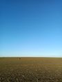
A field near Dřetovice. It could be muddy this time of the year.
Participants
- mvolfik + 3 of his friends who don't have an account (yet)
Expedition
We have been planning a meetup with my friends on this day for over a week. On Friday afternoon, with still no specific plans scheduled, I had a "GUYS, look!" moment when I checked where the Saturday geohash pointed to. A plan was born: I found three buses going to Buštěhrad shortly after noon, created this route, and found three buses going back to Prague from Okoř, with the hope we won't need the last one, because it would be dark and cold by then.
We arrived at Buštěhrad at 13:53 and the first half of the expedition went pretty much as planned, except that we went much slower than anticipated. We found the Buštěhrad slag heap (I'm honestly surprised that a heap of waste has a Wikipedia page in 2 languages), and the obvious act was to climb it. From there, we had a very nice view of the Prague airport, so we spent there some time, listening to the air traffic control radio and planespotting. Then we realized we wouldn't get anywhere this way, and quickly continued to the hash.
The field with the hash was about as muddy as we expected: it was possible to relatively comfortably walk, but our shoes got dirty and heavy after a few tens of meters. At the hash, I revealed a mysterious item I've been carrying with me: a kite (at the time unknowing there was a ribbon for this). However, it was missing two rods from the construction, so I had to go back through the mud to vandalize some bush and fix the construction. Eventually, we succeeded though, and were able to fly the kite around the hash for a few minutes. Getting a photo with the exact coordinates of the hash wasn't exactly easy - I was running around in circles to get the coordinates exactly right, but my phone refused to cooperate: at some point, I was 0.00001 degrees away, which obviously wouldn't suffice, but when I moved in the correct direction, the coordinates displayed weren't changing for a while, until they suddenly changed by much more than needed. Eventually, we succeeded though.
After obtaining all needed documentation of our visit, we realized it took us over two hours to walk less than half of our planned trip. I was strongly advocating for keeping the route and taking the later bus, but was overruled, so we cut our plans and from Libochovičky we went straight to Okoř via the blue tourist route, coming just in time for the 17:13 bus.
Photos
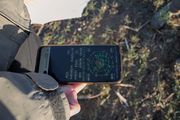
The Hash
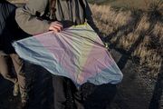
The improvised construction fix of the kite
If you look closely, you might actually see the kite in the sky
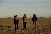
The three of us who don't own a camera, walking through the hashed field
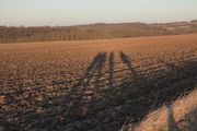
A proof there was actually four of us


Achievements
mvolfik earned the Two to the N achievement
|
mvolfik earned the Fly a Kite Brought by Public Transport, on Land Achievement
|