Difference between revisions of "2024-07-20 41 -72"
m (format fix) |
(Report complete) |
||
| Line 1: | Line 1: | ||
| − | + | {{meetup graticule|date=2024-07-20|lat=41|lon=-72}} | |
| − | |||
| − | |||
| − | |||
| − | |||
| − | |||
| − | |||
| − | |||
| − | |||
== Location == | == Location == | ||
In a parking lot at Bolton Center School. | In a parking lot at Bolton Center School. | ||
| Line 16: | Line 8: | ||
== Plans == | == Plans == | ||
| − | Noting how it had been a while since our last geohashing expedition, MapMan asked if I would like to reach this day's point as it was in an easy to reach location. Since I had plans with friends for the afternoon, I told him that we could do this if we made it quick. After some reheated pizza for lunch and quick unpacking of camping equipment, we were ready to drive out to Bolton at 1: | + | Noting how it had been a while since our last geohashing expedition, MapMan asked if I would like to reach this day's point as it was in an easy to reach location. Since I had plans with friends for the afternoon, I told him that we could do this if we made it quick. After some reheated pizza for lunch and quick unpacking of camping equipment, we were ready to drive out to Bolton at around 1:15 PM. |
== Expedition == | == Expedition == | ||
| − | + | The drive out on Route 6 from Columbia to Bolton was an easy one (with a quick stop at Dunkin for cold drinks along the way). I was surprised to see how elevated the town center was compared to Route 6, having drove up a sizable incline to get out of the valley the highway was in. Approaching the school at around 1:50, we were at first confused as to why Google Maps was leading us in a strange roundabout manner, but it was due to the abundance of one-way signs that were on the school grounds, with a nice patch of trees in the middle of an oblong roundabout standing close to where the hashpoint was. | |
| − | + | We got out in the parking lot and were quick to get into close enough proximity, in a dusty curb island that held a turn sign and a "do not enter" sign on the other side. MapMan stuck an acorn into the ground where he suspected was the closest to the geographic coordinates, and drew a triangle to highlight it (pictured). I wrote "XKCD" in the dirt and he wrote "7/20", then we stood around and beheld the pretty elementary school scenery in solitude, grabbing pictures. The journey back was rather mundane, but it allowed me time to prepare for my plans later that day. Glad I went, I ought to get out and do this more often. ^_^ | |
| − | |||
== Photos == | == Photos == | ||
| − | |||
| − | |||
| − | |||
<gallery perrow="5"> | <gallery perrow="5"> | ||
| + | Image:20240720(1).jpg|Our scribbles in the sand. | ||
| + | Image:20240720 134623.jpg|Playground... | ||
| + | Image:20240720 134628.jpg|... sign... | ||
| + | Image:20240720 134643.jpg|... and field. | ||
| + | Image:Resized 20240720 134724.jpg|We entered... whoops. | ||
</gallery> | </gallery> | ||
== Achievements == | == Achievements == | ||
| − | {{ | + | {{Two to the N achievement |
| − | + | ||
| + | | count = 2 | ||
| + | | date = 2024-07-20 | ||
| + | | latitude = 41 | ||
| + | | longitude = -72 | ||
| + | | name = JBest | ||
| + | | reached = true (optional - include if you are counting coordinates reached) | ||
| + | }} | ||
| − | |||
| − | |||
| − | |||
[[Category:New report]] | [[Category:New report]] | ||
| − | |||
| − | |||
| − | |||
| − | |||
| − | |||
| − | |||
| − | |||
[[Category:Expeditions]] | [[Category:Expeditions]] | ||
| − | |||
[[Category:Expeditions with photos]] | [[Category:Expeditions with photos]] | ||
| − | |||
| − | |||
| − | |||
| − | |||
[[Category:Coordinates reached]] | [[Category:Coordinates reached]] | ||
| − | |||
| − | |||
| − | |||
| − | |||
| − | |||
| − | |||
| − | |||
| − | |||
| − | |||
| − | |||
| − | |||
| − | |||
| − | |||
| − | |||
Revision as of 17:13, 21 July 2024
| Sat 20 Jul 2024 in 41,-72: 41.7758697, -72.4415353 geohashing.info google osm bing/os kml crox |
Location
In a parking lot at Bolton Center School.
Participants
- JBest
- MapMan
Plans
Noting how it had been a while since our last geohashing expedition, MapMan asked if I would like to reach this day's point as it was in an easy to reach location. Since I had plans with friends for the afternoon, I told him that we could do this if we made it quick. After some reheated pizza for lunch and quick unpacking of camping equipment, we were ready to drive out to Bolton at around 1:15 PM.
Expedition
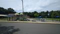
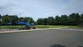
The drive out on Route 6 from Columbia to Bolton was an easy one (with a quick stop at Dunkin for cold drinks along the way). I was surprised to see how elevated the town center was compared to Route 6, having drove up a sizable incline to get out of the valley the highway was in. Approaching the school at around 1:50, we were at first confused as to why Google Maps was leading us in a strange roundabout manner, but it was due to the abundance of one-way signs that were on the school grounds, with a nice patch of trees in the middle of an oblong roundabout standing close to where the hashpoint was.
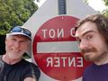
We got out in the parking lot and were quick to get into close enough proximity, in a dusty curb island that held a turn sign and a "do not enter" sign on the other side. MapMan stuck an acorn into the ground where he suspected was the closest to the geographic coordinates, and drew a triangle to highlight it (pictured). I wrote "XKCD" in the dirt and he wrote "7/20", then we stood around and beheld the pretty elementary school scenery in solitude, grabbing pictures. The journey back was rather mundane, but it allowed me time to prepare for my plans later that day. Glad I went, I ought to get out and do this more often. ^_^
Photos
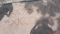
Our scribbles in the sand.
Playground...
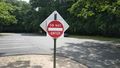
... sign...
... and field.
We entered... whoops.
.jpg)


Achievements
JBest earned the Two to the N achievement
|