Difference between revisions of "2024-07-30 42 -78"
Pedalpusher (talk | contribs) (New report) |
m (Location) |
||
| Line 33: | Line 33: | ||
[[Category:Coordinates reached]] | [[Category:Coordinates reached]] | ||
[[Category:Expeditions with photos]] | [[Category:Expeditions with photos]] | ||
| + | {{location|US|NY|ER}} | ||
Latest revision as of 15:42, 3 August 2024
| Tue 30 Jul 2024 in 42,-78: 42.8942012, -78.7211756 geohashing.info google osm bing/os kml crox |
Location
Edge of Marywood Drive in Cheektowaga
Participants
Expedition
Like my last expedition on the 25th, this was close enough to get to on the way home from work, but only because the weather wasn't great and I drove in. If I had ridden my bike in, I would have had to ride home and drive over maybe after dinner so I got lucky here.
I tried to get out a few minutes early but knew I'd still have to deal with all the traffic on the main thruway of the area. The drive over made me realize I've got a good drive home as those outer suburbs are a mess during rush hour. Except for the volume, it was an easy drive over and I parked in the hash-neighborhood across from the hash. I probably could have turned around and parked by the hash and gotten it, but it was easy enough to jump out of the car for a minute. I was able to get a good reading on the HashDroid app and headed for home. I ended up taking an alternate route to avoid the worst of the traffic on the mainline thruway but was an otherwise good detour for another expedition.
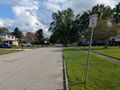
Photos
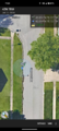
Made it.
View West from the hash.
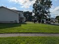
View North to the corner.
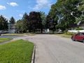
View East across the street.
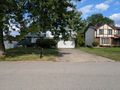
View South toward the main road.

Standard Stupid Grin.
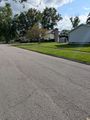
View of the Hash area as I head back to the car.


Ribbons
This user earned the Land geohash achievement
|