Difference between revisions of "2024-08-08 48 16"
(new report) |
(details) |
||
| Line 5: | Line 5: | ||
==Participants== | ==Participants== | ||
*[[User:Fippe|Fippe]] | *[[User:Fippe|Fippe]] | ||
| + | |||
| + | __TOC__ | ||
==Expedition== | ==Expedition== | ||
| − | + | {{User:Fippe/Spree|2024-08-06}} | |
| + | In the afternoon, I walked to ''Wien/Praterstern'', took the subway via ''Wien/Stephansplatz'' to Wien-Westbahnhof, the train to Purkersdorf Central, the bus to ''Allhang/Sportplatzstraße'' and walked the rest of the distance. | ||
| + | |||
| + | Since this was my last day in Austria, I had my suitcase with me, which made the now following hilly ascent challenging. While locating the coordinates, I stumbled through some blackberry bushes, and finally reached them among some grass. After recording proof, I got back on the path and noticed that I had been attacked by raptors, but they did not manage to cut deep. | ||
| + | |||
| + | Afterwards, I walked to the ''Riederberg/Unterer Langleithenweg'' bus stop, took the bus to Purkersdorf Central and the train via Wien-Hütteldorf and Wien Central to the airport. | ||
| + | |||
| + | ==Photos== | ||
| + | <gallery mode="packed" heights="220px"> | ||
| + | 2024-08-08 48 16 01 Site.jpg | My suitcase near the coordinates | ||
| + | 2024-08-08 48 16 03 Geohash.jpg | The Geohash | ||
| + | 2024-08-08 48 16 05 Site.jpg | The site of the Geohash | ||
| + | 2024-08-08 48 16 02 Proof.jpg | Proof | ||
| + | 2024-08-08 48 16 06 Raptor.jpg | Consequences of the raptor attack | ||
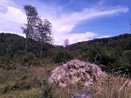
| + | 2024-08-08 48 16 04 Surroundings.jpg | Surroundings | ||
| + | </gallery> | ||
| + | |||
| + | ==Tracklog== | ||
| + | {{tracklog|2024-08-08 48 16 09 Tracklog.gpx}} | ||
| + | |||
| + | ==Missed [[Air Geohash]]es== | ||
| + | Later this day, I flew [https://xkcd.com/1937/ from VIE to HAJ]. | ||
| + | |||
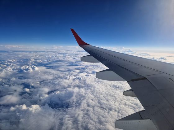
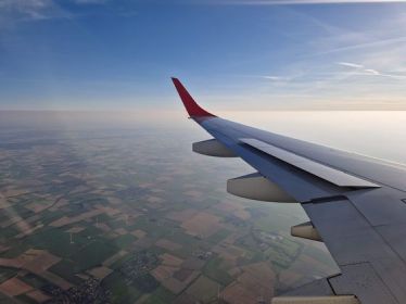
| + | I kept my eyes open for Air Geohashes, and there were three instances where I got into a ten-km radius, but nowhere near close enough. Funny enough, the closest I got to any geohash on the plane was the one that I had reached earlier on land. My window was facing the wrong direction though, so instead I had a look at the river Wien's valley. | ||
| + | |||
| + | <gallery mode="packed" heights="280px"> | ||
| + | 2024-08-08 VIE E195LR OE-LWQ.jpg | OE-LWQ, an Embraer E195LR, at VIE | ||
| + | 2024-08-08 48 16 08 Closest Aerial.jpg | My closest aerial approach to the coordinates I reached earlier | ||
| + | 2024-08-08 48 16 07 Wrong Side.jpg | View to the south-west | ||
| + | </gallery><gallery mode="packed" heights="280px"> | ||
| + | 2024-08-08 49 14 Closest.jpg | Closest distance | ||
| + | 2024-08-08 49 14 Aerial.jpg | and view towards {{egl|2024-08-08|49|14}} in Ražice | ||
| + | 2024-08-08 52 10 Closest.jpg | Closest distance | ||
| + | 2024-08-08 52 10 Aerial.jpg | and view towards {{egl|2024-08-08|52|10}} in Bierbergen | ||
| + | </gallery> | ||
| + | |||
| + | {{tracklog|2024-08 Fippe flights.gpx}}{{square|0a0}}{{square|00a}} Today's flight<br>{{square|a0a}}{{square|a00}} The flight there two days earlier | ||
| + | |||
| + | ==Ribbons== | ||
| + | {{#vardefine:ribbonwidth|100%}} | ||
| + | {{land geohash|date=2024-08-08|latitude=48|longitude=16|name=[[User:Fippe|Fippe]]|image=2024-08-08 48 16 03 Geohash.jpg}} | ||
| + | {{velociraptor geohash|date=2024-08-08|latitude=48|longitude=16|name=[[User:Fippe|Fippe]]|image=2024-08-08 48 16 06 Raptor.jpg}} | ||
| + | {{regional geohashing|count=2|name=[[User:Fippe|Fippe]]|region=[[User:Fippe/Progress#AT126|Wiener Umland/Nordteil]]|image=AT126 regional Fippe.png}} | ||
__NOTOC__ | __NOTOC__ | ||
| Line 14: | Line 58: | ||
[[Category:Expeditions with photos]] | [[Category:Expeditions with photos]] | ||
{{location|AT|NÖ|PL}} | {{location|AT|NÖ|PL}} | ||
| + | {{user categories|user=Fippe|hours=14|tram=6|train=49|bus=15|foot=5}} | ||
Latest revision as of 21:20, 17 August 2024
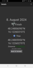
| Thu 8 Aug 2024 in 48,16: 48.2480609, 16.1226031 geohashing.info google osm bing/os kml crox |
Location
This Geohash is located in a forest in Allhang.
Participants
Contents
Expedition
Trip to Wien
Wien-Ottakring ·
Wagram am Wagram ·
Allhang
In the afternoon, I walked to Wien/Praterstern, took the subway via Wien/Stephansplatz to Wien-Westbahnhof, the train to Purkersdorf Central, the bus to Allhang/Sportplatzstraße and walked the rest of the distance.
Since this was my last day in Austria, I had my suitcase with me, which made the now following hilly ascent challenging. While locating the coordinates, I stumbled through some blackberry bushes, and finally reached them among some grass. After recording proof, I got back on the path and noticed that I had been attacked by raptors, but they did not manage to cut deep.
Afterwards, I walked to the Riederberg/Unterer Langleithenweg bus stop, took the bus to Purkersdorf Central and the train via Wien-Hütteldorf and Wien Central to the airport.
Photos
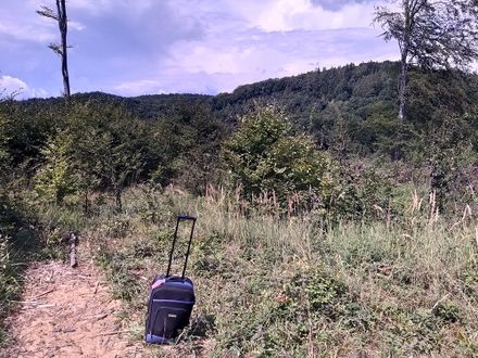
My suitcase near the coordinates
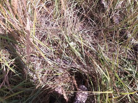
The Geohash
The site of the Geohash
Proof

Consequences of the raptor attack

Surroundings


Tracklog
Missed Air Geohashes
Later this day, I flew from VIE to HAJ.
I kept my eyes open for Air Geohashes, and there were three instances where I got into a ten-km radius, but nowhere near close enough. Funny enough, the closest I got to any geohash on the plane was the one that I had reached earlier on land. My window was facing the wrong direction though, so instead I had a look at the river Wien's valley.
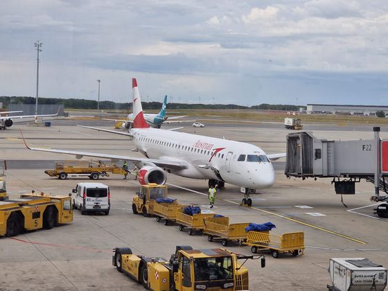
OE-LWQ, an Embraer E195LR, at VIE

My closest aerial approach to the coordinates I reached earlier

View to the south-west


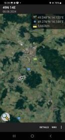
Closest distance
and view towards 2024-08-08 49 14 in Ražice
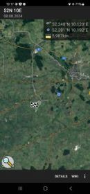
Closest distance
and view towards 2024-08-08 52 10 in Bierbergen


Today's flight
The flight there two days earlier
Ribbons
Fippe earned the Land geohash achievement
|
Fippe earned the Velociraptor Geohash Achievement
|
Fippe earned the Regional geohashing achievement
|
- Meetup on 2024-08-08
- Meetup in 48 16
- Expeditions with tracklogs
- Land geohash achievement
- Velociraptor geohash achievement
- Regional geohashing achievement
- Expeditions
- Coordinates reached
- Expeditions with photos
- Meetup in Bezirk St. Pölten-Land
- Expeditions by Fippe
- Fippe's expeditions by bus
- Fippe's expeditions on foot
- Fippe's expeditions by train
- Fippe's expeditions by tram