Difference between revisions of "2024-08-25 49 11"
m (Location) |
(→Participants) |
||
| Line 15: | Line 15: | ||
<!-- who attended: If you link to your wiki user name in this section, your expedition will be picked up by the various statistics generated for geohashing. You may use three tildes ~ as a shortcut to automatically insert the user signature of the account you are editing with. | <!-- who attended: If you link to your wiki user name in this section, your expedition will be picked up by the various statistics generated for geohashing. You may use three tildes ~ as a shortcut to automatically insert the user signature of the account you are editing with. | ||
--> | --> | ||
| − | [[User:Torodeas|Torodeas]] ([[User talk:Torodeas|talk]]) | + | * [[User:Torodeas|Torodeas]] ([[User talk:Torodeas|talk]]) |
| − | |||
== Expedition == | == Expedition == | ||
Latest revision as of 11:59, 31 August 2024
| Sun 25 Aug 2024 in 49,11: 49.7538654, 11.0136727 geohashing.info google osm bing/os kml crox |
Location
In a forest near Pautzfeld
Participants
Expedition
In a sense, this expedition is remarkably similar to last weeks expedition, but a little bit further north (and so a little longer trip for me). So I depart after lunch, on the exact same connection that gets me to work - just to stay on the line for a little longer than I usually do (and a little longer than last week), until the stop called "Eggolsheim".
From there, I start walking to the hash. I have to cross the canal, which at this point has merged with the river Regnitz (remember last week when my hash was between these two?), which I can only do alongside the frequently used road. It does have a walk / cycle lane attached to it, so it's all good from that perspective, but shortly after the bridge, the road towards Pauzfeld would require me to do a left-hand turn onto it. It does not have a visible walking path, and crossing the road isn't really practical either. Since the hash is west of Pauzfeld anyways, I decide to keep walking towards Schlammersdorf, and then using one of the footpaths into that forest.
I walk through an industrial area, and regrettably some of the roads I saw on my map are actually private roads inside some of these industrial businesses, so I walk all the way to Schlammersdorf proper to get back to a point where I can cross into the woods.
After a short search at the location of the hash, I record proof and proceed back to my train station. I notice that I'm very short on time to catch my train home - otherwise I'll have to wait for an additional hour - but luckily, I can walk much faster than what my app estimated, so I shave off minute by minute until I am back at the train station even with a 3 minute buffer. All good!
Tracklog
Photos

Proof
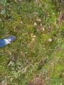
At the hash
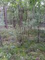
View from hash


Achievements
Torodeas earned the Land geohash achievement
|
Torodeas earned the Public transport geohash achievement
|