Difference between revisions of "2009-02-11 49 10"
imported>Danatar |
|||
| Line 36: | Line 36: | ||
Image:2009-02-11_49_10_panorama.jpg|Left: Vogelsburg monastery, track to Volkach; center: Nordheim on the other side of the Main, Eschersdorf on this side | Image:2009-02-11_49_10_panorama.jpg|Left: Vogelsburg monastery, track to Volkach; center: Nordheim on the other side of the Main, Eschersdorf on this side | ||
Image:2009-02-11_49_10_volkach-townhall.jpg|Volkach town hall | Image:2009-02-11_49_10_volkach-townhall.jpg|Volkach town hall | ||
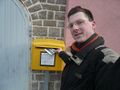
| + | Image:2009-02-11 49 10 hashcard-briefkasten.jpg | ||
Image:2009-02-11 49 10 hashcard1.jpg | Image:2009-02-11 49 10 hashcard1.jpg | ||
Image:2009-02-11 49 10 hashcard2.jpg | Image:2009-02-11 49 10 hashcard2.jpg | ||
Revision as of 16:27, 4 March 2009
| Wed 11 Feb 2009 in Bamberg: 49.8650157, 10.1767613 geohashing.info google osm bing/os kml crox |
Location
Today's location is at the side of a track in a vineyard near Volkach. It's inside the Volkacher Mainschleife (Volkach Main loop) on the slope directly above the borough Escherndorf, at an elevation of about 255 metres.
Country: Germany; state: Bayern (Bavaria, EU:DE:BY); administrative region: Unterfranken; district: Kitzingen
Weather: Würzburg, 9 am: cold, clouded, single snowflakes; Hashpoint, 10 am: snowfall, 2°C; Volkach, 10:30 am: clouded; Hashpoint again, 11:30 am: sunny, some clouds.
Expedition
Danatar
I started at 8:53 and used a route I had never used before, through Estenfeld and Kürnach. It went very well and I reached the hashpoint at 10 o'clock sharp. Shortly before I arrived there, the clouds became darker and it started to snow. I built a snowman and took pictures, then I continued to Volkach.
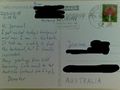
In Volkach, I cycled for a while up and down the old town's streets trying to find a nice postcard with an aerial view of the Mainschleife, so that the hashpoint would be visible. I did not succeed exactly as planned, but I finally found one that showed the hashpoint's slope. I sent it to Joannac before returning to the hashpoint. By then, the snowfall had stopped and the sun had come out. My snowman had completely disappeared, not even a heap of wet snow was left (wtf?? I suspect a crime!). I took more photos, then I cycled home.
I had planned to take a different route to check out possible tracks for future expeditions, but I soon was stopped by a muddy track. Because it would have taken me forever to follow that track, I stayed on the paved road even though that meant a detour. At the prophete bike outlet, I bought some spare parts, including a new odometer/speedometer because the old one (old=4 months) doesn't work anymore. At 13:13 I arrived back home.
This is my second Snowman Geohash, I cycled 56.6 km (home-hp 21.6 km; hp-Volkach-hp 8.7 km; hp-home 26.3 km) (and about 370 m uphill).
Hashcard
Joanna certifies that she got a hashcard from this expedition/
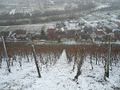
Looking down the slope from the hashpoint
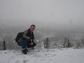
Coordinates reached by snowman
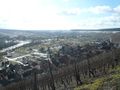
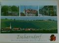
Escherndorf
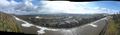
Left: Vogelsburg monastery, track to Volkach; center: Nordheim on the other side of the Main, Eschersdorf on this side
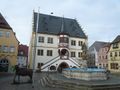
Volkach town hall