Difference between revisions of "2009-02-15 41 -89"
imported>Excellentdude (Finished!) |
imported>ReletBot m (mv template as per Naming conventions) |
||
| Line 36: | Line 36: | ||
| date = 2009-02-15 | | date = 2009-02-15 | ||
| name = excellentdude | | name = excellentdude | ||
| − | }}{{Ambassador | + | }}{{Ambassador |
| latitude = 41 | | latitude = 41 | ||
| longitude = -89 | | longitude = -89 | ||
Revision as of 15:58, 4 April 2009
| Sun 15 Feb 2009 in Sterling: 41.3692524, -89.5834935 geohashing.info google osm bing/os kml crox |
Contents
About
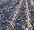
It's February in rural Illinois. If you guessed "harvested corn field", you're correct!
Expedition
After having spent the weekend in northeast Missouri, it was time to head back to mid-Michigan. I stopped briefly at my grandparents' house outside Iowa City, and then headed east on I-80. As luck would have it, the coordinates for several graticules fell near I-80 in Illinois. So I decided to give a couple that were particularly close a shot.
I began in the Sterling, Illinois, graticule. As you might guess, the satellite imagery of this area was not too detailed. There was the small town of Wyanet to the south of the hash, and a north-south road to the west of the hash. Rather than trying to access the cornfield hash through some "city"-dweller's backyard, I decided to head up the road and see how close I could get that way. A house with a good-sized barn and some farm equipment appeared not far north of the hash. I drove in and walked up to the door. I knocked, and a 3- or 4-year-old girl answered the door. I quickly and cautiously backed away and asked if either of her parents were home. Two seconds later her mom appeared. I explained geohashing and what I wanted to do. She seemed slightly confused, explained that is wasn't their land, but thought the owner wouldn't mind. So I proceeded into the harvested cornfield. The hash ended up being farther southeast and much closer to Wyanet than I had originally thought. After trying not to stumble over a multitude of frozen corn stalks, I reached the hash! While at the hash, I took a picture of Wyanet. In the photo below, you are seeing at least two-thirds of Wyanet. On my way back to my car, I quickly found a set of tracks that led straight back to the house! No more stumbling for me!
I then headed back to I-80, where my trip home and geohashing continued...
Achievements
excellentdude earned the Land geohash achievement
|
excellentdude earned the Frozen Geohash Achievement
|
excellentdude earned the Multihash Achievement
|
excellentdude earned the Ambassador achievement
|


