Difference between revisions of "2009-03-08 51 10"
From Geohashing
imported>Relet (→Tracklog) |
imported>Relet (→Photos) |
||
| Line 23: | Line 23: | ||
== Photos == | == Photos == | ||
| + | |||
| + | * [http://relet.net/g2/d/14447-2/P1030459.JPG the path to the top is steep and icy] | ||
| + | * [http://relet.net/g2/d/14452-2/P1030460.JPG and strewn with.. songs.] | ||
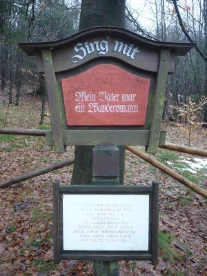
| + | * [http://relet.net/g2/d/14457-2/P1030461.JPG the signs say: "sing along"] | ||
| + | * [http://relet.net/g2/d/14462-2/P1030462.JPG go ahead if you feel like it] | ||
| + | * [http://relet.net/g2/d/14467-2/P1030463.JPG and strike a pose] | ||
| + | * [http://relet.net/g2/d/14477-2/P1030464.JPG then there are more songs] | ||
| + | * [http://relet.net/g2/d/14482-2/P1030465.JPG beware of the poetry] | ||
| + | * [http://relet.net/g2/d/14472-2/P1030466.JPG the roads got better along the way] | ||
| + | * [http://relet.net/g2/d/14487-2/P1030467.JPG slightly] | ||
| + | * [http://relet.net/g2/d/14492-2/P1030468.JPG fog over the forest] | ||
| + | * [http://relet.net/g2/d/14497-2/P1030469.JPG took the wrong road. is that a river in our direction?] | ||
| + | * [http://relet.net/g2/d/14502-2/P1030472.JPG the path down is steep and slippery, though] | ||
| + | * [http://relet.net/g2/d/14507-2/P1030473.JPG a magnificent forest] | ||
| + | * [http://relet.net/g2/d/14512-2/P1030474.JPG that would have been the right road to take] | ||
| + | * [http://relet.net/g2/d/14517-2/P1030475.JPG indeed, there is a river - what we saw was more snow though.] | ||
| + | * [http://relet.net/g2/d/14522-2/P1030477.JPG after a bit of searching, it was crossed without wet feet. reception was bad though] | ||
| + | * [http://relet.net/g2/d/14527-2/P1030478.JPG a somewhat stupid grin] | ||
| + | * [http://relet.net/g2/d/14532-2/P1030479.JPG the beautiful town of Stolberg] | ||
| + | * [http://relet.net/g2/d/14537-2/P1030481.JPG narrow roads and large buses] | ||
| + | * [http://relet.net/g2/d/14542-2/P1030482.JPG medieval houses] | ||
| + | * [http://relet.net/g2/d/14547-2/P1030480.JPG beautifully decorated (unfortunately, we were in a bit of hurry)] | ||
[[Category:Expeditions]] | [[Category:Expeditions]] | ||
[[Category:Expeditions with photos]] | [[Category:Expeditions with photos]] | ||
[[Category:Coordinates reached]] | [[Category:Coordinates reached]] | ||
Revision as of 08:42, 10 March 2009
| Sun 8 Mar 2009 in 51,10: 51.5792666, 10.9768719 geohashing.info google osm bing/os kml crox |
Participants
Plans
Expedition
(has happened, yet to be written up)
Tracklog
http://www.everytrail.com/view_trip.php?trip_id=143694
Photos
- the path to the top is steep and icy
- and strewn with.. songs.
- the signs say: "sing along"
- go ahead if you feel like it
- and strike a pose
- then there are more songs
- beware of the poetry
- the roads got better along the way
- slightly
- fog over the forest
- took the wrong road. is that a river in our direction?
- the path down is steep and slippery, though
- a magnificent forest
- that would have been the right road to take
- indeed, there is a river - what we saw was more snow though.
- after a bit of searching, it was crossed without wet feet. reception was bad though
- a somewhat stupid grin
- the beautiful town of Stolberg
- narrow roads and large buses
- medieval houses
- beautifully decorated (unfortunately, we were in a bit of hurry)
