Difference between revisions of "2009-03-09 52 0"
imported>Benjw m (→Shiny ribbons earned: +multihash ribbon) |
imported>Benjw m (→Expedition: typo) |
||
| Line 17: | Line 17: | ||
Most of the way there, I was walking along a concrete track between two fields. This ended at some kind of storage area with large piles of crates, about 20m from the hash, which was out into a ploughed but empty field. The earth was quite solid so I walked over and found the hashpoint. A few photos were taken, but there wasn't much of interest, and I get to see plenty of farms in this graticule. | Most of the way there, I was walking along a concrete track between two fields. This ended at some kind of storage area with large piles of crates, about 20m from the hash, which was out into a ploughed but empty field. The earth was quite solid so I walked over and found the hashpoint. A few photos were taken, but there wasn't much of interest, and I get to see plenty of farms in this graticule. | ||
| − | I then walked back. Still nobody around at all. Never mind, too late now! I had two | + | I then walked back. Still nobody around at all. Never mind, too late now! I had two cups of thermos tea and another sandwich, and then carried on to the [[2009-03-09 52 -0|next expedition]]. |
== Shiny ribbons earned == | == Shiny ribbons earned == | ||
Revision as of 21:54, 14 March 2009
| Mon 9 Mar 2009 in Cambridge: 52.6171403, 0.2402096 geohashing.info google osm bing/os kml crox |
Today's hashpoint was just outside the village of Outwell, near Wisbech, in a field that looks to be part of Beaupré Hall Farm. Benjw found the hashpoint, during the second part of a Triple Hash expedition -- the other parts are here and here.
Expedition
Benjw
I set off from the Norwich hashpoint a little after 3pm, and took the A47 and A1122 roads west to Outwell village. The journey was reasonable but at times a little slow, as there was plenty of traffic and no space for anyone to overtake. Still, I wasn't in much of a hurry, so I sat back, listened to some music and ate some melted plastic cheese spread sandwiches as I went along.
I got to Outwell just over an hour later, and quickly found the farm I was looking for. I had a wander around, looking for someone to ok my mission, but there was nobody there at all -- neither in the house nor around the farm buildings. Odd. But since I had already walked halfway to the hashpoint looking for someone to ask about it, I figured it wouldn't hurt to carry on.
Most of the way there, I was walking along a concrete track between two fields. This ended at some kind of storage area with large piles of crates, about 20m from the hash, which was out into a ploughed but empty field. The earth was quite solid so I walked over and found the hashpoint. A few photos were taken, but there wasn't much of interest, and I get to see plenty of farms in this graticule.
I then walked back. Still nobody around at all. Never mind, too late now! I had two cups of thermos tea and another sandwich, and then carried on to the next expedition.
Shiny ribbons earned
Benjw earned the Land geohash achievement
|
Benjw earned the Multihash Achievement
|
Photographic documentation
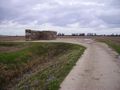
Another hashpoint in another field.
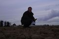
Ben at the hashpoint.
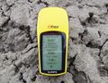
GPS proof that the point was reached.
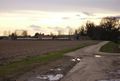
Looking back towards the farm from the hashpoint.


