Difference between revisions of "2009-05-13 68 19"
imported>The ru m |
imported>Fippe (Location) |
||
| Line 28: | Line 28: | ||
[[Category:Expeditions with photos]] | [[Category:Expeditions with photos]] | ||
[[Category:Coordinates reached]] | [[Category:Coordinates reached]] | ||
| + | {{location|SE|BD}} | ||
Revision as of 23:29, 7 June 2019
| Wed 13 May 2009 in 68,19: 68.2956643, 19.4288156 geohashing.info google osm bing/os kml crox |
The hashpoint was on the northern shore of a cape/mountain extending into the lake Torneträsk, a few km from the Stenbacken train station (no longer in use).
the ru
I walked 10.6 km to reach this hashpoint. On the way there, I went straight across the hills. Stenbacken translates quite literally into "rocky slope" and I would have a hard time coming up with a better name for this area. I had to constantly leap between rocks or haul myself across boulders. When I reached the hashpoint I had walked 4.5 km. On the way back, I took a route some distance to the west, closer to the shore. It was longer but much easier.
Wildlife seen: I scared three ptarmigans that took off, didn't have time to get any picture of them.
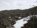
The terrain
- 2009-05-13 68 19 boulder.jpg
Geohasher included for size comparison (actually, this was one of the smaller boulders)
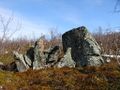
This expedition rocks!
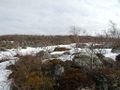
The hashpoint
- 2009-05-13 68 19 proof.jpg
The Internet strikes again
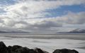
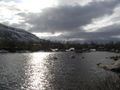
View west over Torneträsk
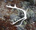
Reindeer antler
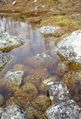
Love the colors in this one


