Difference between revisions of "2009-05-17 50 11"
imported>Reinhard m |
imported>Paintedhell (report JJ) |
||
| Line 7: | Line 7: | ||
A sunny bike trip of 70-100 km with Reinhard, Juja and her drag-along. | A sunny bike trip of 70-100 km with Reinhard, Juja and her drag-along. | ||
| + | I'm sure Juja will write something about it soon. Right?! | ||
| − | + | ---[[User:Manu|Manu]] | |
| − | ---[[User: | + | On Saturday evening I had convinced Manu and Reinhard to lead the way to the hash which was impossible to be found without a GPS gadget, so now I somehow feel obliged to write the report at least. Here it is! |
| + | |||
| + | ===Expedition: J&J=== | ||
| + | After having a party on Saturday, we got up late and had to clean the leftovers (okay, I got up very late and J. cleaned the leftovers all alone, I'm so lazy), so in the end we were a bit late at the place where we should meet Manu and Reinhard with our bikes. They were already waiting and had their revenge on the first few kilometers to Lobeda, where they easily lost us while we were still rubbing sleep and pollen out of our eyes. In Rutha we caught up and went on a little more relaxed, using the bike way via Maua, Rothenstein, Jägersdorf, Kahla, Freienorla and Niederkrossen. From there, the road wound up to Friedebach and after that we entered the deep, dark forest, where another rather steep way led us to the top of the hill. The Geohash was located nearly on the top, and after we despised a nice grassy way which would probably have brought us right there, we had to go some hundred meters over hedge and ditch to reach it. With aching legs we finally stood on the top of the middle-Thuringian world enjoying our picnic (of course, our little hashcots were also enjoying it - after all, they didn't have to walk themselves!). We went down to Uhlstädt on the other side of the hill and looked for something to eat then - we finally found a restaurant whose name I fortunately have already forgotten (but Manu might remember!), but it was the only one in the whole town and was surrounded by a faint smell of old toilets. The food was not too good either, so avoid it if you can! Soon after that, we decided to go seperate ways, as Reinhard was planning a tour of over 100km conquering a number of additional mountains and we were already tired, so we said Goodbye and went back the easy way by the river again. Nice tour, might have been 70-80km, and a four-course meal as our reward at home. I'm looking forward to going again in nice company like this! :) ---[[User:Paintedhell|Paintedhell]] | ||
| + | |||
| + | ===Additions: Manu and Reinhard=== | ||
<gallery caption="Photo Gallery" widths="200px" heights="200px" perrow="2"> | <gallery caption="Photo Gallery" widths="200px" heights="200px" perrow="2"> | ||
Image:Geo_20090517_50_11_01.jpg|Tux, Wischi, Karl and Mauz seemingly enjoyed the expedition. | Image:Geo_20090517_50_11_01.jpg|Tux, Wischi, Karl and Mauz seemingly enjoyed the expedition. | ||
| + | Image:Geo_20090517_50_11_2.jpg|Reinhard was the first (and only one) to stand on the actual point in the middle of thicket. | ||
</gallery> | </gallery> | ||
| + | |||
| + | ===Achievements=== | ||
| + | None, again? | ||
[[Category:Expeditions]] | [[Category:Expeditions]] | ||
[[Category:Coordinates reached]] | [[Category:Coordinates reached]] | ||
| + | [[Category:Expeditions with photos]] | ||
Revision as of 17:49, 18 May 2009
| Sun 17 May 2009 in 50,10: 50.7104108, 10.4668811 geohashing.info google osm bing/os kml crox |
A sunny bike trip of 70-100 km with Reinhard, Juja and her drag-along.
I'm sure Juja will write something about it soon. Right?!
---Manu
On Saturday evening I had convinced Manu and Reinhard to lead the way to the hash which was impossible to be found without a GPS gadget, so now I somehow feel obliged to write the report at least. Here it is!
Expedition: J&J
After having a party on Saturday, we got up late and had to clean the leftovers (okay, I got up very late and J. cleaned the leftovers all alone, I'm so lazy), so in the end we were a bit late at the place where we should meet Manu and Reinhard with our bikes. They were already waiting and had their revenge on the first few kilometers to Lobeda, where they easily lost us while we were still rubbing sleep and pollen out of our eyes. In Rutha we caught up and went on a little more relaxed, using the bike way via Maua, Rothenstein, Jägersdorf, Kahla, Freienorla and Niederkrossen. From there, the road wound up to Friedebach and after that we entered the deep, dark forest, where another rather steep way led us to the top of the hill. The Geohash was located nearly on the top, and after we despised a nice grassy way which would probably have brought us right there, we had to go some hundred meters over hedge and ditch to reach it. With aching legs we finally stood on the top of the middle-Thuringian world enjoying our picnic (of course, our little hashcots were also enjoying it - after all, they didn't have to walk themselves!). We went down to Uhlstädt on the other side of the hill and looked for something to eat then - we finally found a restaurant whose name I fortunately have already forgotten (but Manu might remember!), but it was the only one in the whole town and was surrounded by a faint smell of old toilets. The food was not too good either, so avoid it if you can! Soon after that, we decided to go seperate ways, as Reinhard was planning a tour of over 100km conquering a number of additional mountains and we were already tired, so we said Goodbye and went back the easy way by the river again. Nice tour, might have been 70-80km, and a four-course meal as our reward at home. I'm looking forward to going again in nice company like this! :) ---Paintedhell
Additions: Manu and Reinhard
- Photo Gallery

Tux, Wischi, Karl and Mauz seemingly enjoyed the expedition.
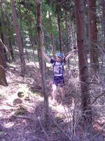
Reinhard was the first (and only one) to stand on the actual point in the middle of thicket.


Achievements
None, again?