Difference between revisions of "2009-05-28 50 11"
imported>Danatar (correcting map link) |
imported>Paintedhell |
||
| Line 24: | Line 24: | ||
---[[User:Reinhard|Reinhard]] | ---[[User:Reinhard|Reinhard]] | ||
| + | ===Expedition: Jens & Uli (non-geohashers)=== | ||
| + | When you do strange things like chasing random points on maps in about 50km distance, people start to take notice. So I recently tried to explain the whole geohashing concept to two of my colleagues. One of them owns a little GPS gadget himself, so he seemed to be interested and found a nice point to go on Wednesday. I was still licking my wounds from [[2009-05-24 50 11|last Sunday]], it was windy and cloudy and everything, so I declined the invitation for a bike tour to the point and let them go themselves (last but not least, they both had half a day off and I went to work meanwhile). I hear they made it and maybe one of them will write something, give me a photo or tell me what to write about it ;) Might be a [[Puppet Master Geohash]] for me, but I think I don't like that concept too much, so I won't claim it :) ---[[User:Paintedhell|Paintedhell]] | ||
<gallery caption="Photo Gallery" widths="200px" heights="200px" perrow="2"> | <gallery caption="Photo Gallery" widths="200px" heights="200px" perrow="2"> | ||
Revision as of 13:47, 29 May 2009
| Thu 28 May 2009 in 50,11: 50.9109198, 11.7966617 geohashing.info google osm bing/os kml crox |
Contents
Location
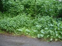
Today's geo hash was located in a forest near the road between Waldeck and Bobeck.
Expedition: Manu
As I spent the evening before in Jena I thought the geohash would be easy to reach on my way to work in Leipzig in the morning. So I stood up half an hour earlier and until I parked my car on the side of the road only about 30 metres away from the hash point I even worried that it would be too easy! But this should not be the case. Immediately after entering the tight underbrush I stood at a very steep slope, which my GPS device told me to climb down. It was wet and muddy, but I tried to find a way down. When I finally made it within five metres to the hash point it began to drift away on the display due to the bad reception in the forest. I hurried to follow the signal climbing up the slope again, whereas I nearly lay down in the mud, until I reached the street again. Disappointed I reentered the forest, took some photos of me in the underbrush (unfortunately I forgot to bring my camera so I could only use my mobile phone and therefore photo quality is low), while the spot on the display was still wandering around me. Nevertheless I claim "coordinates reached". The note I brought with me to leave it for Reinhard like a few weeks ago I took back again, because I wasn't sure that he would find it in the evening. Furthermore I wanted to leave the shrubs quickly as I am always afraid of ticks - later I constantly thought something was crawling on my leg or neck, although I haven't found one yet. Did I mention that my shoes and trousers became very dirty - not really adequate for working in an office and cleanroom...
---Manu
Expedition: Reinhard
In the afternoon, while I was still at work, there were two heavy showers, which made me afraid that this one's going to become a Drowned Rat Geohash. But the weather got better and when I started from work at 6 pm even the sun was shining and many roads were dry, yet. After 19.4 km I arrived near the hashpoint at 6:42 pm, slipped plastic bags over my bike shoes and went into the copse. Quickly I got to the hashpoint, took some photos and got back to the bike.
I planned to take a small detour via Hermsdorf on my way back, but when I discovered that incredibly beautiful paved bike path through the Mühltal, which started in Bad Klosterlausnitz and lead to Kursdorf, I had to ride this one till the end, where I discovered another nice bike path going towards Gera, parallel to the major road B7. So this ended up in Gera, where I chose a road back to Hermsdorf that I hadn't tracked, yet, as well. After 102 km I was back at my working place at 10 pm to get my rucksack and ride the last 7 km home.
---Reinhard
Expedition: Jens & Uli (non-geohashers)
When you do strange things like chasing random points on maps in about 50km distance, people start to take notice. So I recently tried to explain the whole geohashing concept to two of my colleagues. One of them owns a little GPS gadget himself, so he seemed to be interested and found a nice point to go on Wednesday. I was still licking my wounds from last Sunday, it was windy and cloudy and everything, so I declined the invitation for a bike tour to the point and let them go themselves (last but not least, they both had half a day off and I went to work meanwhile). I hear they made it and maybe one of them will write something, give me a photo or tell me what to write about it ;) Might be a Puppet Master Geohash for me, but I think I don't like that concept too much, so I won't claim it :) ---Paintedhell
- Photo Gallery
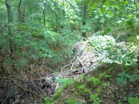
The way to the hash point.
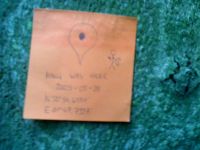
Blurred photo of my note on a tree in the shrubs.
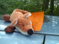
Hashfox sitting on the car.

A really stupid and unfavourable picture.
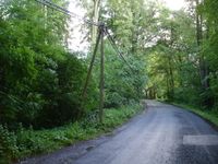
The road between Waldeck and Bobeck, near the hashpoint.
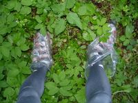
Manu recommended me to wear plastic bags around my shoes when doing the muddy expedition. Thank you! :)
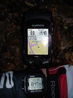
At the hashpoint (GPS drifting).
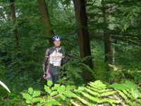
Me with less than a stupid grin.
Looks like someone entered the wood before, just 10 m from where I did. ;-)


