Difference between revisions of "Milwaukee, Wisconsin"
imported>ReletBot m (Bot: Automated text replacement (-irc.peeron.com +carabiner.peeron.com)) |
imported>RocketMac (→Expeditions) |
||
| Line 23: | Line 23: | ||
==Expeditions== | ==Expeditions== | ||
| + | * [[2012-05-10 43 -87|May 10th, 2012]] -- [[User:RocketMac|RocketMac]] visited a bustling street corner before meeting his wife for drinks. | ||
* [[2011-12-21 43 -87|December 21st, 2011]] -- [[User:RocketMac|RocketMac]] dragged his wife along on their way to date night | * [[2011-12-21 43 -87|December 21st, 2011]] -- [[User:RocketMac|RocketMac]] dragged his wife along on their way to date night | ||
* [[2011-10-22 43 -87|October 22nd, 2011]] -- [[User:RocketMac|RocketMac]] and his wife used the algorithm as a random lunch generator. | * [[2011-10-22 43 -87|October 22nd, 2011]] -- [[User:RocketMac|RocketMac]] and his wife used the algorithm as a random lunch generator. | ||
Revision as of 07:23, 14 May 2012
| Appleton | Manitowoc | Manistee, MI |
| Fond du Lac | Milwaukee | Muskegon, MI |
| Schaumburg, IL | Kenosha | Holland, MI |
|
Today's location: not yet announced | ||
Today's Location: [Milwaukee, WI]
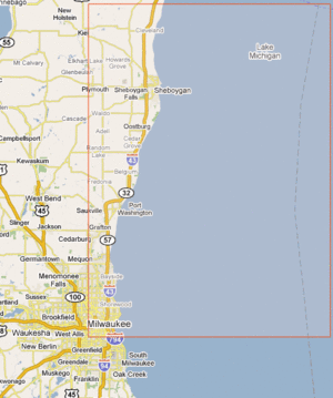
The Milwaukee, WI graticule is located near latitude 43, longitude -87. Unfortunately, Lake Michigan occupies most of the graticule, although it does cover a few more lake cities like Port Washington and Sheboygan. It also contains any communities along the I-43 and STH-57 corridors north to the community of Newton in Sheboygan County. In the Milwaukee area this graticule is roughly bordered by 76th street(STH-181) on the West and Lincoln Avenue on the South.
This graticule includes many nice areas of the Greater Milwaukee Area including the hip and trendy East Side and Downtown Milwaukee areas, as well as the North Shore suburbs. Most of the area to the north of Milwaukee in this graticule is farm land. Smaller Ozaukee County communities and Sheboygan and its suburbs are included.
Expeditions
- May 10th, 2012 -- RocketMac visited a bustling street corner before meeting his wife for drinks.
- December 21st, 2011 -- RocketMac dragged his wife along on their way to date night
- October 22nd, 2011 -- RocketMac and his wife used the algorithm as a random lunch generator.
- October 13th, 2011 -- RocketMac loitered in the parking lot of a labor union headquarters.
- October 7th, 2011 -- RocketMac loitered in the parking lot of a country club at 10:30pm.
- December 26, 2010 -- Bassoon, Brian, Dedehawk, and Jessie invade from the Fond du Lac graticule to head to Sheboygan for a hash aside Lake Michigan. First hash in this graticule!
