Difference between revisions of "2009-10-27 49 11"
imported>Dawidi (writeup + photos (more to follow)) |
imported>Dawidi (more pictures) |
||
| Line 15: | Line 15: | ||
<gallery> | <gallery> | ||
Image:2009-10-27 49 11 gps.jpg|Coordinates reached. | Image:2009-10-27 49 11 gps.jpg|Coordinates reached. | ||
| − | Image:2009-10-27 49 11 widi tomcat.jpg| | + | Image:2009-10-27 49 11 widi tomcat flash.jpg|Flash-lit hashers. |
| + | Image:2009-10-27 49 11 widi tomcat.jpg|LED-lit hashers. | ||
Image:2009-10-27 49 11 lightmark.jpg|First geohash lightmark of the season. | Image:2009-10-27 49 11 lightmark.jpg|First geohash lightmark of the season. | ||
| − | Image:2009-10-27 49 11 etterzhausen.jpg|View west across the valley to Etterzhausen | + | Image:2009-10-27 49 11 north.jpg|View north. |
| + | Image:2009-10-27 49 11 up.jpg|View into the treetops. | ||
| + | Image:2009-10-27 49 11 quarry laser.jpg|Looking into the quarry (and shining a laser beam at the other end). | ||
| + | Image:2009-10-27 49 11 etterzhausen.jpg|View west across the valley to Etterzhausen. | ||
</gallery> | </gallery> | ||
Revision as of 22:31, 27 October 2009
| Tue 27 Oct 2009 in Nürnberg, Germany: 49.0266602, 11.9988727 geohashing.info google osm bing/os kml crox |
In the forest on Greifenberg hill, east of Etterzhausen. Dawidi's geocache "Greifenberg" (GC1A2DX) is within 300m of the hashpoint.
dawidi with Tomcat
We met at 18:00 on the footbridge over the Naab river in Mariaort, and after a close encounter of the jogger kind, cycled along the B8 to the quarry, and parked our bikes about 1/3 of the way up the hill on the quarry's western edge, then stumbled the last 200 meters uphill to the hash. Since it wasn't really that cold yet (over 10°C anyway), we spent some time experimenting with cameras and lights, before heading back to the edge of the quarry - which probably would have been a more spectacular sight in daylight.
Shortly after 20:00, we returned via Mariaort to Prüfening and had a nice lasagna dinner before splitting up.
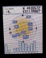
Coordinates reached.
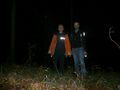
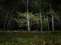
Flash-lit hashers.
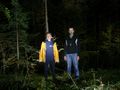
LED-lit hashers.
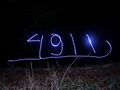
First geohash lightmark of the season.
View north.
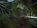
View into the treetops.
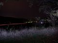
Looking into the quarry (and shining a laser beam at the other end).
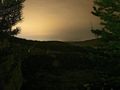
View west across the valley to Etterzhausen.


