Difference between revisions of "2009-11-13 40 -89"
From Geohashing
imported>Dvdllr |
imported>Dvdllr |
||
| Line 1: | Line 1: | ||
| − | |||
| − | |||
| − | |||
| − | |||
{{meetup graticule | {{meetup graticule | ||
| lat=40 | | lat=40 | ||
| Line 8: | Line 4: | ||
| date=2009-11-13 | | date=2009-11-13 | ||
}} | }} | ||
| − | |||
| − | |||
| − | |||
== Location == | == Location == | ||
| − | + | On the west side of Detroit Avenue near Birchwood Street, across from the downtown public works building and the police station. | |
== Participants == | == Participants == | ||
| − | [[User:dvdllr|David]] | + | * [[User:dvdllr|David]] & Rachel |
== Plans == | == Plans == | ||
| − | + | I saw that the hashpoint was in a relatively accessable spot in my hometown, and what's more, close to my house (765 meters as the crow flies). I decided to leave work early today so as to make it to the hashpoint at 4:00. The only real planning I needed was to decide whether to take bikes or to walk. | |
| − | + | == Expedition == | |
| + | Description coming | ||
| − | + | == Photos == | |
| − | == | ||
| + | <gallery perrow="4"> | ||
| + | Image:2009-11-13 40 -89 1.jpg | Figuring out the route to take | ||
| + | Image:2009-11-13 40 -89 2.jpg | The public works water tower, as seen from the hashpoint | ||
| + | Image:2009-11-13 40 -89 3.jpg | On the left, the driveway to the public works building... | ||
| + | Image:2009-11-13 40 -89 4.jpg | ...and on the right, the police station driveway | ||
| + | Image:2009-11-13 40 -89 5.jpg | Date and time on the cellphone (very blurry but you might be able to make it out) | ||
| + | Image:2009-11-13 40 -89 Peeron.png | Proof of location | ||
| + | </gallery> | ||
| − | == | + | == Achievements == |
| + | {{land geohash | ||
| + | | latitude = 40 | ||
| + | | longitude = -89 | ||
| + | | date = 2009-11-13 | ||
| + | | name = [[User:Dvdllr|David]] | ||
| + | | image = 2009-11-13 40 -89 3.jpg | ||
| + | }} | ||
| + | {{Bicycle geohash | ||
| − | == | + | | latitude = 40 |
| − | + | | longitude = -89 | |
| − | + | | date = 2009-11-13 | |
| − | + | | name = [[User:Dvdllr|David]] | |
| − | + | | distance = 1.15 kilometers | |
| − | + | | image = 2009-11-13 40 -89 3.jpg | |
| − | + | }} | |
| − | + | {{No_batteries_geohash | |
| + | |||
| + | | latitude = 40 | ||
| + | | longitude = -89 | ||
| + | | date = 2009-11-13 | ||
| + | | name = [[User:Dvdllr|David]] | ||
| + | | image = 2009-11-13 40 -89 3.jpg | ||
| + | }} | ||
| + | {{Easy_geohash | ||
| − | + | | latitude = 40 | |
| + | | longitude = -89 | ||
| + | | date = 2009-11-13 | ||
| + | | name = [[User:Dvdllr|David]] | ||
| + | | image = 2009-11-13 40 -89 3.jpg | ||
| + | }} | ||
| − | |||
| − | |||
| − | |||
| − | |||
[[Category:Expeditions]] | [[Category:Expeditions]] | ||
| − | |||
[[Category:Expeditions with photos]] | [[Category:Expeditions with photos]] | ||
| − | |||
[[Category:Expedition without GPS]] | [[Category:Expedition without GPS]] | ||
| − | |||
| − | |||
| − | |||
[[Category:Coordinates reached]] | [[Category:Coordinates reached]] | ||
| − | |||
| − | |||
| − | |||
| − | |||
| − | |||
| − | |||
| − | |||
| − | |||
| − | |||
| − | |||
Revision as of 03:35, 14 November 2009
| Fri 13 Nov 2009 in 40,-89: 40.6064666, -89.4734952 geohashing.info google osm bing/os kml crox |
Location
On the west side of Detroit Avenue near Birchwood Street, across from the downtown public works building and the police station.
Participants
- David & Rachel
Plans
I saw that the hashpoint was in a relatively accessable spot in my hometown, and what's more, close to my house (765 meters as the crow flies). I decided to leave work early today so as to make it to the hashpoint at 4:00. The only real planning I needed was to decide whether to take bikes or to walk.
Expedition
Description coming
Photos
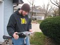
Figuring out the route to take
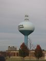
The public works water tower, as seen from the hashpoint
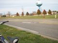
On the left, the driveway to the public works building...
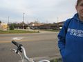
...and on the right, the police station driveway
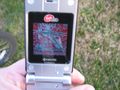
Date and time on the cellphone (very blurry but you might be able to make it out)
- 2009-11-13 40 -89 Peeron.png
Proof of location


Achievements
David earned the Land geohash achievement
|
David earned the Bicycle geohash achievement
|
David earned the No Batteries Geohash Achievement
|
David has visited an Easy Geohash
|