Difference between revisions of "2010-05-03 49 -122"
imported>Jiml m (Fill in some data) |
imported>Thepiguy (Done) |
||
| Line 1: | Line 1: | ||
| − | |||
| − | |||
| − | |||
| − | |||
| − | |||
| − | |||
{{meetup graticule | {{meetup graticule | ||
| lat=49 | | lat=49 | ||
| Line 10: | Line 4: | ||
| date=2010-05-03 | | date=2010-05-03 | ||
}} | }} | ||
| − | |||
| − | |||
| − | |||
| − | |||
| − | |||
== Participants == | == Participants == | ||
* [[User:thepiguy]] | * [[User:thepiguy]] | ||
| + | * [[User:MylSh|Mylsh]] | ||
== Plans == | == Plans == | ||
| − | |||
| − | |||
Is that a cemetery? [[user:thepiguy]] will head out after work (maybe 17:30ish?) | Is that a cemetery? [[user:thepiguy]] will head out after work (maybe 17:30ish?) | ||
| + | == Expedition == | ||
| + | therpiguy and MylSh met at the Broadway-Commercial Skytrain station in what may be the most perfectly executed transit rendezvous ever. It was a short ride to the bus station followed by a slightly longer bus ride in which neither Geohasher knew which stop they wanted, but still managed to pick the correct one. | ||
| + | They meandered into what was indeed a cemetery, and quickly located the coordinates, and the most recent Coffin Potato Geohash winner. They photographed the GPS and the head stone, but decided to move to a more respectable location back on the road, before taking their stupid grin photo. | ||
| + | All in all: a very simple hash with some very nice weather. | ||
| − | + | == Photos == | |
| − | == | + | <gallery> |
| − | < | + | Image:2010-05-03_49_-122_street.JPG|Off the bus and 100m to go. |
| − | + | Image:2010-05-03_49_-122_gps.jpg|We are here! | |
| − | + | Image:2010-05-03_49_-122_hom.JPG|Our "winner." | |
| − | + | Image:2010-05-03_49_-122_cemetery.JPG|It was also a very nice day! | |
| − | + | Image:2010-05-03_49_-122_hashers.JPG|Hasher. Staring directly into the sun. | |
| − | |||
| − | |||
| − | Image: | ||
| − | -- | ||
| − | |||
</gallery> | </gallery> | ||
| + | ==Ribbons== | ||
| + | {{ | ||
| + | Coffin potato | latitude = 49 | longitude = -122 | date = 2010-05-03 | deceased = Hom Sing Dong | name = thepiguy and MylSh | image = 2010-05-03_49_-122_hom.JPG | ||
| + | }} | ||
| − | |||
| − | |||
| − | |||
| − | |||
| − | |||
| − | |||
| − | |||
| − | |||
| − | |||
| − | |||
| − | |||
[[Category:Expeditions with photos]] | [[Category:Expeditions with photos]] | ||
| − | |||
| − | |||
| − | |||
| − | |||
| − | |||
[[Category:Coordinates reached]] | [[Category:Coordinates reached]] | ||
| − | |||
| − | |||
| − | |||
| − | |||
| − | |||
| − | |||
| − | |||
| − | |||
| − | |||
| − | |||
Revision as of 04:04, 6 May 2010
| Mon 3 May 2010 in 49,-122: 49.2427043, -122.9893408 geohashing.info google osm bing/os kml crox |
Contents
Participants
Plans
Is that a cemetery? user:thepiguy will head out after work (maybe 17:30ish?)
Expedition
therpiguy and MylSh met at the Broadway-Commercial Skytrain station in what may be the most perfectly executed transit rendezvous ever. It was a short ride to the bus station followed by a slightly longer bus ride in which neither Geohasher knew which stop they wanted, but still managed to pick the correct one.
They meandered into what was indeed a cemetery, and quickly located the coordinates, and the most recent Coffin Potato Geohash winner. They photographed the GPS and the head stone, but decided to move to a more respectable location back on the road, before taking their stupid grin photo.
All in all: a very simple hash with some very nice weather.
Photos
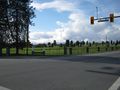
Off the bus and 100m to go.
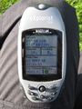
We are here!
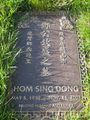
Our "winner."
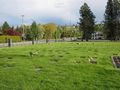
It was also a very nice day!

Hasher. Staring directly into the sun.


Ribbons
thepiguy and MylSh certifies that Hom Sing Dong earned the Coffin Potato Achievement
|