Difference between revisions of "2010-05-16 47 11"
imported>Zb (new report) |
imported>Zb (Yay report!) |
||
| Line 1: | Line 1: | ||
| − | |||
<!-- If you did not specify these parameters in the template, please substitute appropriate things for IMAGE, LAT, LON, and DATE (YYYY-MM-DD format) | <!-- If you did not specify these parameters in the template, please substitute appropriate things for IMAGE, LAT, LON, and DATE (YYYY-MM-DD format) | ||
| Line 15: | Line 14: | ||
__NOTOC__ | __NOTOC__ | ||
== Location == | == Location == | ||
| − | + | NW of Aying, close to the RR Crossing of the S-Bahn and road St 2070 and next to a big intersection (St 2070, St 2078) | |
== Participants == | == Participants == | ||
| − | + | [[user:Zb|zb]] | |
| + | |||
| + | == Expedition == | ||
| + | Despite the cold wind and the cloudy sky, it looked like it might be a fun bike ride. I went South via Neuperlach, Neubiberg and Ottobrunn, took a wrong turn somewhere and ended up doing a detour via Brunntal and Hofolding towards Aying. | ||
| − | + | Just when I got there, a München-bound train left Aying which made taking pictures a lot more fun. The spot itself was easily found because the landmarks were all there on the satellite images. | |
| − | |||
| − | + | The way back was along Egmating and on through the forest to Grasbrunn. | |
| − | |||
| − | + | I came home with 59 km on the trip display and feeling quite hungry. | |
| − | |||
== Photos == | == Photos == | ||
| − | < | + | <gallery perrow="2"> |
| − | Image: | + | Image:2010-05-15 47 11 Aying 0001.jpg | The bike on the left is my preferred method of transportation when going geohashing. The train is a class 423, leaving Aying towards München... |
| − | -- | + | Image:2010-05-15 47 11 Aying 0002.jpg | ... and passing the coordinates, which are just behind the V-shaped signal, between the rail tracks and the field. |
| − | + | Image:2010-05-15 47 11 Aying 0004.jpg | The coords are 21 km from München East (Ostbahnhof). This shed contains the machinery for the automated bars and lights of the RR crossing. | |
| + | Image:2010-05-15 47 11 Aying 0005.jpg | It looks like there are lead-acid batteries inside that might release hydrogen. | ||
</gallery> | </gallery> | ||
| − | |||
| − | |||
| − | |||
| − | |||
| − | |||
| − | |||
| − | |||
[[Category:New report]] | [[Category:New report]] | ||
| − | |||
| − | |||
| − | |||
| − | |||
| − | |||
| − | |||
| − | |||
[[Category:Expeditions]] | [[Category:Expeditions]] | ||
| − | |||
[[Category:Expeditions with photos]] | [[Category:Expeditions with photos]] | ||
| − | |||
[[Category:Expedition without GPS]] | [[Category:Expedition without GPS]] | ||
| − | |||
| − | |||
| − | |||
[[Category:Coordinates reached]] | [[Category:Coordinates reached]] | ||
| − | |||
| − | |||
| − | |||
| − | |||
| − | |||
| − | |||
| − | |||
| − | |||
| − | |||
| − | |||
Revision as of 20:10, 16 May 2010
| Sun 16 May 2010 in 47,11: 47.9723779, 11.7647325 geohashing.info google osm bing/os kml crox |
Location
NW of Aying, close to the RR Crossing of the S-Bahn and road St 2070 and next to a big intersection (St 2070, St 2078)
Participants
Expedition
Despite the cold wind and the cloudy sky, it looked like it might be a fun bike ride. I went South via Neuperlach, Neubiberg and Ottobrunn, took a wrong turn somewhere and ended up doing a detour via Brunntal and Hofolding towards Aying.
Just when I got there, a München-bound train left Aying which made taking pictures a lot more fun. The spot itself was easily found because the landmarks were all there on the satellite images.
The way back was along Egmating and on through the forest to Grasbrunn.
I came home with 59 km on the trip display and feeling quite hungry.
Photos
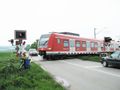
The bike on the left is my preferred method of transportation when going geohashing. The train is a class 423, leaving Aying towards München...
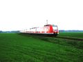
... and passing the coordinates, which are just behind the V-shaped signal, between the rail tracks and the field.
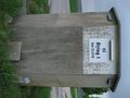
The coords are 21 km from München East (Ostbahnhof). This shed contains the machinery for the automated bars and lights of the RR crossing.
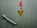
It looks like there are lead-acid batteries inside that might release hydrogen.


