Difference between revisions of "2010-08-07 52 0"
From Geohashing
imported>Sourcerer |
imported>Sourcerer m |
||
| Line 30: | Line 30: | ||
Image:2010_08_07_52_0_juggernaut.jpg|Juggernaut Evidence. | Image:2010_08_07_52_0_juggernaut.jpg|Juggernaut Evidence. | ||
</gallery> | </gallery> | ||
| + | |||
| + | [[Category: Meetup on 2010-08-07]] | ||
| + | [[Category: Meetup in 52 0]] | ||
Revision as of 19:42, 28 August 2010
Location
In a elderberry tree near Syderstone, Norfolk, United Kingdom. The hash point was right beside a bridle path and very easy to get to. Wikiloc
| Sat 7 Aug 2010 in Cambridge: 52.8714800, 0.7146075 geohashing.info google osm bing/os kml crox |
Participants
Expedition
This was Sourcerer, Neil's first ever geohash. He visited the tree as part of a day trip to the north Norfolk coast. Brambles made it impossible to reach the exact coordinates but the GPS receiver said it was within 3 metres. As the device is accurate to +/- 4 metres under ideal conditions, I believe this counts.
Image Gallery

Neil. Manic -Grin.
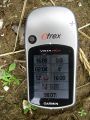
Satnav Evidence.
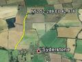
Google Earth Path.
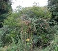
The Elderberry Tree and Brambles.
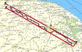
Juggernaut Evidence.


