Difference between revisions of "2010-11-07 52 1"
From Geohashing
imported>Sourcerer (Created page with '== Location == Close to Sutton Corn Mill and the Weavers' Way long distance path, between the Norfolk Broads villages of Stalham and Hickling. {{meetup graticule | lat=52 …') |
imported>HiroProtagonist m (typo in category name) |
||
| Line 34: | Line 34: | ||
[[Category:Expeditions with photos]] | [[Category:Expeditions with photos]] | ||
[[Category:Coordinates reached]] | [[Category:Coordinates reached]] | ||
| − | [[Category:Meetup on 2010-11 | + | [[Category:Meetup on 2010-11-07]] |
[[Category:Meetup in 51 1]] | [[Category:Meetup in 51 1]] | ||
Revision as of 16:54, 9 November 2010
Location
Close to Sutton Corn Mill and the Weavers' Way long distance path, between the Norfolk Broads villages of Stalham and Hickling.
| Sun 7 Nov 2010 in Norwich: 52.7609772, 1.5510646 geohashing.info google osm bing/os kml crox |
Participants
Expedition
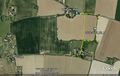
Sourcerer (Neil) extended a shopping trip to include this hashpoint. The hashpoint lay about 110 metres off the Weavers' Way long distance path. It could be reached by going round three sides of a newly planted field of what might have been wheat. The walk, including a diversion to look at the mill, was only 1.1 km long. It was a sunny November day and the temperature was about 8 Celsius.
Tracklog
The track is logged here at Wikiloc.
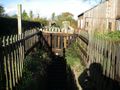
Photo Gallery
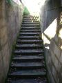
Unexpected Steps
Unexpected Steps
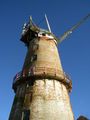
Sutton Corn Mill
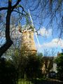
Sutton Corn Mill
Google Earth Track


