Difference between revisions of "2010-11-21 51 1"
From Geohashing
imported>Sourcerer (Created page with '== Location == A small bottle bank in Taunton Road, Walton, Felixtowe, Suffolk, UK. {{meetup graticule | lat=51 | lon=1 | date=2010-11-21 | graticule_name=Cante…') |
imported>Sourcerer m (→Photo Gallery) |
||
| Line 22: | Line 22: | ||
<gallery perrow="3"> | <gallery perrow="3"> | ||
Image:2010-11-21_51_1_Sourcerer_1.JPG|The hashpoint next to the Bottle Bank | Image:2010-11-21_51_1_Sourcerer_1.JPG|The hashpoint next to the Bottle Bank | ||
| − | Image:2010-11-21_51_1_Sourcerer_2.JPG|Google Earth View | + | Image:2010-11-21_51_1_Sourcerer_2.JPG|Google Earth View with GPS Path |
</gallery> | </gallery> | ||
Revision as of 17:23, 21 November 2010
Location
A small bottle bank in Taunton Road, Walton, Felixtowe, Suffolk, UK.
| Sun 21 Nov 2010 in Canterbury: 51.9714152, 1.3468424 geohashing.info google osm bing/os kml crox |
Participants
Expedition
Sourcerer Neil feared the hashpoint was right inside the bottle bank but it turned out to be about 2.5 metres south east on a grassy lawn. Three miles south of the haspoint there is a car park overlooking the Felixtowe docks. The foot passenger ferry to Harwich leaves from here too. This is an interesting spot with a good view with lots of shipping activity. Really big container ships dock here and the tugs are docked close to the car park.
Photo Gallery
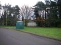
The hashpoint next to the Bottle Bank
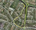
Google Earth View with GPS Path

