Difference between revisions of "2011-03-05 49 8"
imported>Koepfel |
imported>FippeBot m (Location) |
||
| Line 36: | Line 36: | ||
[[Category:Expeditions with photos]] | [[Category:Expeditions with photos]] | ||
[[Category:Coordinates reached]] | [[Category:Coordinates reached]] | ||
| + | {{location|DE|BW|KA|city=true}} | ||
Latest revision as of 05:43, 9 August 2019
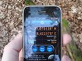
| Sat 5 Mar 2011 in 49,8: 49.0751054, 8.4224241 geohashing.info google osm bing/os kml crox |
Contents
Location
In the Hardtwald, the large forest north of Karlsruhe.
Participants
Expedition
Koepfel
Yet another rather uneventful expedition. I grabbed my bike, rode through the suburb called Waldstadt (=forest town) into the actual forest, revisiting 2009-01-25 49 8 on the way, my very first hashpoint. From there, I went along the Pfinz-Entlastungskanal, a canal build through the northern suburbs of Karlsruhe to take water off the Pfinz river.
The hashpoint was only a little south of that canal, somewhere in the forest, but still within Karlsruhe city limits.
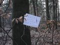
I waited for 16:00 for any other hashers but only a few hikers went by. Before leaving, I wrote another marker in the path and biked back home.
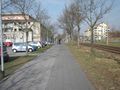
Biking through the Waldstadt
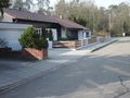
Revisiting my first hashpoint.
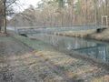
Along the Pfinz-Entlastungskanal
There I am
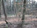
It's a forest.
For people passing by.


