Difference between revisions of "2011-04-16 52 12"
imported>Pari (Created page with "{{subst:Expedition |lat = 52 |lon = 12 |date = 2011-04-16 }}") |
imported>Pari |
||
| Line 1: | Line 1: | ||
| − | |||
| − | |||
| − | |||
| − | |||
| − | |||
| − | |||
| − | |||
| − | |||
| − | |||
| − | |||
{{meetup graticule | {{meetup graticule | ||
| lat=52 | | lat=52 | ||
| Line 15: | Line 5: | ||
}} | }} | ||
| − | |||
__NOTOC__ | __NOTOC__ | ||
== Location == | == Location == | ||
| − | + | The hash was near the town of Neuruppin, on a field next to a railway line. | |
== Participants == | == Participants == | ||
| − | + | * [[user:pari|pari]] | |
| + | * Alex | ||
== Plans == | == Plans == | ||
| − | + | Getting near the hash by car, park the car, walk to the hash. | |
| + | |||
| + | When seeing the aerial photo, I first mistook the railway line for a public road which would have allowed us to drive almost directly to the destination. Realizing there was no such, we planned to leave the car in the nearest village and explore the surrounding area by foot. | ||
== Expedition == | == Expedition == | ||
| − | + | We started in Berlin where we took the Autobahn to get out of city towards Neuruppin. After 30 minutes of driving, we left it and took some smaller roads to reach the village next to the hash. At the road leading out of Märkisch Linden, we stopped the car, took the GPS and walked towards countryside. | |
| + | |||
| + | After passing some locals who didn't seem to see a lot of strangers, we crossed the railway as seen on the map and spotted a dirt road along the track. After a few hundred meters, the field with the hash lay right before us. The typical smell of the dung under our feet didn't keep us from having a direct look at the hash. | ||
| − | + | Pretty straightforward. Maybe the next time can be a little challenge again. :) | |
| − | |||
== Photos == | == Photos == | ||
| Line 36: | Line 29: | ||
Image:2010-##-## ## ## Alpha.jpg | Witty Comment | Image:2010-##-## ## ## Alpha.jpg | Witty Comment | ||
--> | --> | ||
| − | <gallery perrow=" | + | <gallery perrow="4"> |
| + | Image:2011-04-16 52 12 001.jpg | walking through the village near the hash | ||
| + | Image:2011-04-16 52 12 002.jpg | railway with a dirt road next to it | ||
| + | Image:2011-04-16 52 12 004.jpg | we're there (yay!) | ||
| + | Image:2011-04-16 52 12 005.jpg | the hash | ||
| + | Image:2011-04-16 52 12 007.jpg | view back to the village Märkisch Linden | ||
| + | Image:2011-04-16 52 12 009.jpg | happy about the successful expedition | ||
| + | Image:2011-04-16 52 12 map.png | the last meters | ||
</gallery> | </gallery> | ||
| − | |||
| − | |||
| − | |||
| − | |||
| − | |||
| − | |||
| − | |||
| − | |||
| − | |||
| − | |||
| − | |||
| − | |||
| − | |||
| − | |||
| − | |||
[[Category:Expeditions]] | [[Category:Expeditions]] | ||
| − | |||
[[Category:Expeditions with photos]] | [[Category:Expeditions with photos]] | ||
| − | |||
| − | |||
| − | |||
| − | |||
[[Category:Coordinates reached]] | [[Category:Coordinates reached]] | ||
| − | |||
| − | |||
| − | |||
| − | |||
| − | |||
| − | |||
| − | |||
| − | |||
| − | |||
| − | |||
Revision as of 14:16, 17 April 2011
| Sat 16 Apr 2011 in 52,12: 52.9341509, 12.7544222 geohashing.info google osm bing/os kml crox |
Location
The hash was near the town of Neuruppin, on a field next to a railway line.
Participants
- pari
- Alex
Plans
Getting near the hash by car, park the car, walk to the hash.
When seeing the aerial photo, I first mistook the railway line for a public road which would have allowed us to drive almost directly to the destination. Realizing there was no such, we planned to leave the car in the nearest village and explore the surrounding area by foot.
Expedition
We started in Berlin where we took the Autobahn to get out of city towards Neuruppin. After 30 minutes of driving, we left it and took some smaller roads to reach the village next to the hash. At the road leading out of Märkisch Linden, we stopped the car, took the GPS and walked towards countryside.
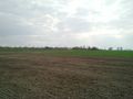
After passing some locals who didn't seem to see a lot of strangers, we crossed the railway as seen on the map and spotted a dirt road along the track. After a few hundred meters, the field with the hash lay right before us. The typical smell of the dung under our feet didn't keep us from having a direct look at the hash.
Pretty straightforward. Maybe the next time can be a little challenge again. :)
Photos
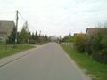
walking through the village near the hash
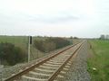
railway with a dirt road next to it
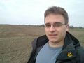
we're there (yay!)
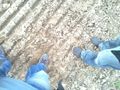
the hash
view back to the village Märkisch Linden
happy about the successful expedition
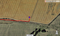
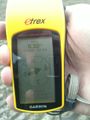
the last meters


