Difference between revisions of "2011-04-21 -43 172"
From Geohashing
imported>ShadowHash |
imported>ShadowHash |
||
| Line 25: | Line 25: | ||
== Photos == | == Photos == | ||
{{gallery|width=200|height=200|lines=2 | {{gallery|width=200|height=200|lines=2 | ||
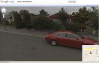
| − | |Image:2011-04-21--43-172GoogleView.jpg| | + | |Image:2011-04-21--43-172GoogleView.jpg|Google Maps street view of the hashpoint. |
| | | | ||
}} | }} | ||
Revision as of 01:38, 26 April 2011
| Thu 21 Apr 2011 in -43,172: -43.5303058, 172.6045881 geohashing.info google osm bing/os kml crox |
Location
Christchurch, New Zealand
Participants
Plans
As the hashpoint was on the side of a suburban street, I drove there after work.
Expedition
Piece of pi. Easy as cake. My hash marker (see photos) probably didn't last long - it was very windy, and sellotape doesn't stick to asphalt very well.
Photos
|
Achievements
ShadowHash earned the Land geohash achievement
|
ShadowHash earned the No Batteries Geohash Achievement
|
well, I didn't use GPS, only Googly maps...
ShadowHash has visited an Easy Geohash
|
sort of - I did have to drive out of my way to get there
