Difference between revisions of "2011-05-14 49 -121"
imported>Robyn (boat) |
imported>Robyn (We tried, but not too hard. We had a lot of fun.) |
||
| Line 1: | Line 1: | ||
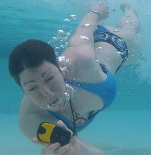
| + | This expedition is probably our most fun example of how geohashing can make a day more interesting even if you don't try really hard to get to the geohash. | ||
| + | [[File:2011-05-14 49 -122.robyn.jpg|thumb|left]] | ||
| − | |||
| − | |||
| − | |||
| − | |||
| − | |||
| − | |||
| − | |||
| − | |||
| − | |||
{{meetup graticule | {{meetup graticule | ||
| lat=49 | | lat=49 | ||
| Line 23: | Line 16: | ||
== Participants == | == Participants == | ||
| − | * Robyn | + | * [[User:Robyn|Robyn]] |
| − | * Wade | + | * [[User:Wade|Wade]] |
== Plans == | == Plans == | ||
| − | Wade and Robyn | + | Wade and Robyn received a gift of a night in the resort quite near here, and it looked as though the hot springs outlet into the lake might be near the geohash. Armed with Wade's new waterproof camera, we planned an underwater attempt. |
== Expedition == | == Expedition == | ||
| − | < | + | <gallery perrow="5"> |
| + | File:2011-05-14 49 -122.1driving.jpg|Robyn and Wade drove out to the lake where the geohash was. | ||
| + | File:2011-05-14 49 -122.2fivekm.jpg|The spot was just over five kilometres from the end of the dock. | ||
| + | File:2011-05-14 49 -122.bumperboat.jpg|We weren't sure whether this boat would go that far in a straight line. | ||
| + | File:2011-05-14 49 -122.pedalboat.jpg|These boats might be too slow, and also wet and cold. | ||
| + | File:2011-05-14 49 -121.thataway.jpg|The lake was very rough and the wind rising. | ||
| + | </gallery> | ||
| − | + | We were thought we might jump in and get underwater at the geohash, but we wanted to stay dry and safe on the way there and back. There were a wide variety of rental boats available, but we couldn't find an appropriate compromise between speed, safety, comfort and price. The nature of the facility that prevented us from approaching the site on foot dampened our enthusiasm for being underwater at the site, so we found a cleaner, warmer and more comfortable spot to be underwater: one of the resort pools, filled with naturally heated hot-springs water. | |
| − | |||
| − | |||
| − | |||
| − | |||
| − | |||
<gallery perrow="5"> | <gallery perrow="5"> | ||
| + | File:2011-05-14 49 -122.seadoo.jpg|This one would be fast, but likely wet and cold. | ||
| + | File:2011-05-14 49 -122.motorboat.jpg|This boat was fast and probably dry, but would cost $90 to rent. | ||
| + | File:2011-05-14 49 -121.tourboat.jpg|This boat would be safe, but not guaranteed to go to the geohash. | ||
| + | File:2011-05-14 49 -122.keepout.jpg|We were barred from walking close to the geohash around the edge of the lake. | ||
| + | File:2011-05-14 49 -122.wade.jpg|So we went back to the resort and tried to find our way underwater from there. | ||
</gallery> | </gallery> | ||
| − | + | ||
| − | |||
| − | |||
| − | |||
| − | |||
| − | |||
| − | |||
| − | |||
| − | |||
| − | |||
| − | |||
| − | |||
| − | |||
| − | |||
| − | |||
[[Category:Expeditions]] | [[Category:Expeditions]] | ||
| − | |||
[[Category:Expeditions with photos]] | [[Category:Expeditions with photos]] | ||
| − | |||
| − | |||
| − | |||
| − | |||
| − | |||
| − | |||
| − | |||
| − | |||
| − | |||
[[Category:Coordinates not reached]] | [[Category:Coordinates not reached]] | ||
| − | + | [[Category:Not reached - Did not attempt]] | |
| − | |||
| − | |||
| − | |||
| − | [[Category:Not reached - Did not attempt]] | ||
| − | |||
Revision as of 06:33, 16 May 2011
This expedition is probably our most fun example of how geohashing can make a day more interesting even if you don't try really hard to get to the geohash.
| Sat 14 May 2011 in 49,-121: 49.3463619, -121.8243191 geohashing.info google osm bing/os kml crox |
Location
In the water on the west shore of Harrison Lake.
Participants
Plans
Wade and Robyn received a gift of a night in the resort quite near here, and it looked as though the hot springs outlet into the lake might be near the geohash. Armed with Wade's new waterproof camera, we planned an underwater attempt.
Expedition
We were thought we might jump in and get underwater at the geohash, but we wanted to stay dry and safe on the way there and back. There were a wide variety of rental boats available, but we couldn't find an appropriate compromise between speed, safety, comfort and price. The nature of the facility that prevented us from approaching the site on foot dampened our enthusiasm for being underwater at the site, so we found a cleaner, warmer and more comfortable spot to be underwater: one of the resort pools, filled with naturally heated hot-springs water.


