Difference between revisions of "2011-05-26 52 1"
From Geohashing
imported>Sourcerer (Created page with "== Location == In a field 400 metres north of the Norfolk Broads river Chet, Loddon, Norfolk, UK. {{meetup graticule | lat=52 | lon=1 | date=2011-05-26 | gratic...") |
imported>Sourcerer |
||
| Line 1: | Line 1: | ||
| − | |||
| − | |||
| − | |||
| − | |||
{{meetup graticule | {{meetup graticule | ||
| lat=52 | | lat=52 | ||
| Line 8: | Line 4: | ||
| date=2011-05-26 | | date=2011-05-26 | ||
| graticule_name=Norwich | | graticule_name=Norwich | ||
| − | | graticule_link=Norwich, United Kingdom}} | + | | graticule_link=Norwich, United Kingdom |
| + | }} | ||
| + | |||
| + | == Location == | ||
| + | |||
| + | In a field 400 metres north of the Norfolk Broads river Chet, Loddon, Norfolk, UK. | ||
== Participants == | == Participants == | ||
| Line 20: | Line 21: | ||
== Photo Gallery == | == Photo Gallery == | ||
| − | <gallery | + | <gallery> |
Image:2011-05-26_52_1_Sourcerer_0.jpg|Google Earth View | Image:2011-05-26_52_1_Sourcerer_0.jpg|Google Earth View | ||
Image:2011-05-26_52_1_Sourcerer_1.jpg|The Hashpoint | Image:2011-05-26_52_1_Sourcerer_1.jpg|The Hashpoint | ||
| Line 32: | Line 33: | ||
{{expedition summaries|2011-05-26}} | {{expedition summaries|2011-05-26}} | ||
| − | + | [[Category:Expeditions]] | |
| − | |||
| − | |||
| − | |||
[[Category:Expeditions with photos]] | [[Category:Expeditions with photos]] | ||
[[Category:Coordinates reached]] | [[Category:Coordinates reached]] | ||
| − | |||
| − | |||
Revision as of 15:29, 22 August 2012
| Thu 26 May 2011 in Norwich: 52.5419800, 1.4904530 geohashing.info google osm bing/os kml crox |
Contents
Location
In a field 400 metres north of the Norfolk Broads river Chet, Loddon, Norfolk, UK.
Participants
The Expedition
This was an easy one. A small detour on the commute home from work, park on the road-side and walk 160 metres down a track and public footpath. There was assess into the field that looked as though it had been created by deer. The field edge was less than 30 metres from the hashpoint. It was a pleasant spot and sunny but with storm clouds not far away. Later we had some much needed rain.
Photo Gallery
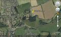
Google Earth View
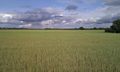
The Hashpoint
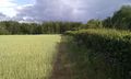
The Hashpoint
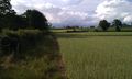
The Hashpoint

Manic Grin


Other Geohashing Expeditions and Plans on This Day
Expeditions and Plans
| 2011-05-26 | ||
|---|---|---|
| Norwich, United Kingdom | Sourcerer | In a field 400 metres north of the Norfolk Broads river Chet, Loddon, Norfo... |
| Sheffield, United Kingdom | Monty | Locke Park, Barnsley, UK. |