Difference between revisions of "2011-05-30 53 -0"
From Geohashing
imported>Sourcerer (Created page with "== Location == North east of Carlton-le-Moorland on Navenby Lane near Newark-on-Trent, Lincolnshire, UK. {{meetup graticule | lat=53 | lon=-0 | date=2011-05-30 | graticule_name...") |
imported>Sourcerer |
||
| Line 16: | Line 16: | ||
== Expedition == | == Expedition == | ||
| − | + | This was a perfect wet day, road hashpoint. The GPS receiver distance dropped right down to zero without even getting out of the car. The evidence photo shows one metre with the receiver propped up on the dashboard. After a most relaxing weekend with lots of curry and beer, I was returning home by a slower but shorter route to take in this point which was only three miles off the main road. | |
| − | |||
== Image Gallery == | == Image Gallery == | ||
<gallery perrow="3"> | <gallery perrow="3"> | ||
| − | Image: | + | Image:2011-05-30_53_-0_Sourcerer_1.jpg|Google Earth Path |
| − | Image: | + | Image:2011-05-30_53_-0_Sourcerer_2.jpg|The soggy wet hashpoint |
| − | + | Image:2011-05-30_53_-0_Sourcerer_3.jpg|The GPS receiver | |
| − | Image: | ||
| − | |||
</gallery> | </gallery> | ||
| − | |||
| − | |||
== Other geohashing expeditions on the same day == | == Other geohashing expeditions on the same day == | ||
| Line 38: | Line 33: | ||
[[Category:Meetup in 53 -0]] | [[Category:Meetup in 53 -0]] | ||
[[Category:Expeditions]] | [[Category:Expeditions]] | ||
| − | |||
| − | |||
| − | |||
[[Category:Coordinates reached]] | [[Category:Coordinates reached]] | ||
[[Category:Expeditions with photos]] | [[Category:Expeditions with photos]] | ||
| − | |||
| − | |||
Revision as of 21:42, 30 May 2011
Contents
Location
North east of Carlton-le-Moorland on Navenby Lane near Newark-on-Trent, Lincolnshire, UK.
| Mon 30 May 2011 in Hull: 53.1178768, -0.6393012 geohashing.info google osm bing/os kml crox |
Participants
Expedition
This was a perfect wet day, road hashpoint. The GPS receiver distance dropped right down to zero without even getting out of the car. The evidence photo shows one metre with the receiver propped up on the dashboard. After a most relaxing weekend with lots of curry and beer, I was returning home by a slower but shorter route to take in this point which was only three miles off the main road.
Image Gallery
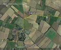
Google Earth Path

The soggy wet hashpoint
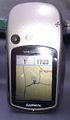
The GPS receiver


Other geohashing expeditions on the same day
Expeditions and Plans
| 2011-05-30 | ||
|---|---|---|
| Washington (West), District of Columbia | Someone went | Between 12 and 1pm, we are going to the hashpoint in Frederick,_Maryland for this date, ... |
| Frederick, Maryland | Travis Low, Daughter | Midway between Leesburg and Purcellville, on State Route 77. |
| Cleveland, Ohio | Jschleappi, Teh Lauren | Some sort of corporate industrial park? Hash point is in the parking lot, ... |
| Surrey, British Columbia | Someone went | located in Langley. |
| Hull, United Kingdom | Sourcerer | North east of Carlton-le-Moorland on Navenby Lane near Newark-on-Trent, Lin... |