Difference between revisions of "2011-10-02 -36 174"
imported>Greenslime m |
imported>Greenslime m (new hash) |
||
| Line 17: | Line 17: | ||
== Expedition == | == Expedition == | ||
| − | + | Fairly straightforward, as mentioned above. Land was still vacant, with For Sale signage out the front. As per Satellite image, the hash location was near a small stand of stone fruit trees out the back, currently in Spring-time flower. Next door is the vineyard with its threatening signage. Vacant plot was behind Resene Paint Shop, which may have provided the paint for the artwork out the back that Li'll Homie insisted I take his photo with. He is standing on a compost bin - random! | |
| − | |||
| − | |||
| − | |||
== Photos == | == Photos == | ||
| − | |||
| − | |||
| − | |||
<gallery perrow="5"> | <gallery perrow="5"> | ||
| + | File:2011-10-02 -36 174 Satellite imagery.JPG|Hash is by a small stand of fruit trees which I figured out on the ground | ||
| + | File:2011-10-02 -36 174 Vacant Plot.JPG.jpg|The vacant plot next to Resene Paint Shop | ||
| + | File:2011-10-02 -36 174 Stand of Trees.JPG.jpg|Stand of fruit trees where the hash point lies | ||
| + | File:2011-10-02 -36 174 Neighbouring Vineyard.jpg|Vineyard next door | ||
| + | File:2011-10-02 -36 174 Artwork and onion grass.jpg|Artwork, onion grass and NZ Native Cabbage Tree | ||
| + | File:2011-10-02 -36 174 Lill Homie Action.jpg|Li'll Homie is such a poser! | ||
</gallery> | </gallery> | ||
== Achievements == | == Achievements == | ||
| − | |||
| − | |||
| − | |||
| − | |||
| − | |||
| − | |||
| − | |||
| − | |||
| − | |||
[[Category:Expeditions]] | [[Category:Expeditions]] | ||
| − | + | [[Category:Expeditions with photos]] | |
| − | [[Category:Expeditions with photos]] | ||
| − | |||
| − | |||
| − | |||
| − | |||
| − | |||
[[Category:Coordinates reached]] | [[Category:Coordinates reached]] | ||
| − | |||
| − | |||
| − | |||
| − | |||
| − | |||
| − | |||
| − | |||
| − | |||
| − | |||
| − | |||
Revision as of 00:09, 2 October 2011
| Sun 2 Oct 2011 in -36,174: -36.8560839, 174.6337055 geohashing.info google osm bing/os kml crox |
Location
Vacant block of land, Henderson, Auckland, New Zealand
Participants
- Greenslime
- Li'll Homie
Plans
Move to location via car, exit vehicle, assault hash. Hopefully there has been no building on this piece of land since Google maps took the street view
Expedition
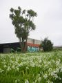
Fairly straightforward, as mentioned above. Land was still vacant, with For Sale signage out the front. As per Satellite image, the hash location was near a small stand of stone fruit trees out the back, currently in Spring-time flower. Next door is the vineyard with its threatening signage. Vacant plot was behind Resene Paint Shop, which may have provided the paint for the artwork out the back that Li'll Homie insisted I take his photo with. He is standing on a compost bin - random!
Photos
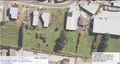
Hash is by a small stand of fruit trees which I figured out on the ground
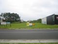
The vacant plot next to Resene Paint Shop
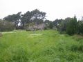
Stand of fruit trees where the hash point lies
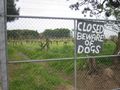
Vineyard next door
Artwork, onion grass and NZ Native Cabbage Tree

Li'll Homie is such a poser!


