Difference between revisions of "2011-10-13 43 -87"
imported>Benjw m (→Expedition: typo) |
imported>Eldin m (clean up template and check categories.) |
||
| Line 1: | Line 1: | ||
| − | |||
| − | |||
| − | |||
| − | |||
| − | |||
| − | |||
| − | |||
| − | |||
| − | |||
{{meetup graticule | {{meetup graticule | ||
| lat=43 | | lat=43 | ||
| Line 14: | Line 5: | ||
}} | }} | ||
| − | |||
== Location == | == Location == | ||
| − | |||
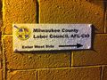
The parking lot of the [http://milwaukeelabor.org Milwaukee County Labor Council]. In fact, right up against the North wall. | The parking lot of the [http://milwaukeelabor.org Milwaukee County Labor Council]. In fact, right up against the North wall. | ||
== Participants == | == Participants == | ||
| − | |||
[[User:RocketMac|RocketMac]] - Taking a detour out of my way home from work | [[User:RocketMac|RocketMac]] - Taking a detour out of my way home from work | ||
== Plans == | == Plans == | ||
| − | |||
This is the second hashpoint for [[43,-87|this graticule]] in a week that could be reached by pulling into a parking spot. Just like the [[2011-10-07 43 -87|last one]], this was a bit out of my way, but it was too good to pass up. | This is the second hashpoint for [[43,-87|this graticule]] in a week that could be reached by pulling into a parking spot. Just like the [[2011-10-07 43 -87|last one]], this was a bit out of my way, but it was too good to pass up. | ||
== Expedition == | == Expedition == | ||
| − | |||
It was raining when I left the house today and throughout the work day it went from drizzle to pouring and back again. While the point is right up against the wall, I was pretty sure I could just pull into a parking spot and call it "close enough" if the rain was too heavy at that moment. | It was raining when I left the house today and throughout the work day it went from drizzle to pouring and back again. While the point is right up against the wall, I was pretty sure I could just pull into a parking spot and call it "close enough" if the rain was too heavy at that moment. | ||
| Line 41: | Line 27: | ||
After that, I was on my way home. | After that, I was on my way home. | ||
| − | |||
| − | |||
| − | |||
| − | |||
| − | |||
== Photos == | == Photos == | ||
| − | |||
| − | |||
| − | |||
<gallery perrow="5"> | <gallery perrow="5"> | ||
Image:2011-10-13 43 -87 01.jpg | There I am! | Image:2011-10-13 43 -87 01.jpg | There I am! | ||
| Line 61: | Line 39: | ||
== Achievements == | == Achievements == | ||
{{#vardefine:ribbonwidth|800px}} | {{#vardefine:ribbonwidth|800px}} | ||
| − | |||
{{land geohash | {{land geohash | ||
| latitude = 43 | | latitude = 43 | ||
| Line 84: | Line 61: | ||
| image = | | image = | ||
}} | }} | ||
| − | |||
| − | |||
| − | |||
| − | |||
| − | |||
| − | |||
| − | |||
| − | |||
[[Category:Expeditions]] | [[Category:Expeditions]] | ||
[[Category:Expeditions with photos]] | [[Category:Expeditions with photos]] | ||
| − | |||
| − | |||
| − | |||
| − | |||
| − | |||
| − | |||
[[Category:Coordinates reached]] | [[Category:Coordinates reached]] | ||
| − | |||
| − | |||
| − | |||
| − | |||
| − | |||
| − | |||
| − | |||
| − | |||
| − | |||
| − | |||
| − | |||
Revision as of 05:49, 12 April 2013
| Thu 13 Oct 2011 in 43,-87: 43.0255078, -87.9862337 geohashing.info google osm bing/os kml crox |
Location
The parking lot of the Milwaukee County Labor Council. In fact, right up against the North wall.
Participants
RocketMac - Taking a detour out of my way home from work
Plans
This is the second hashpoint for this graticule in a week that could be reached by pulling into a parking spot. Just like the last one, this was a bit out of my way, but it was too good to pass up.
Expedition
It was raining when I left the house today and throughout the work day it went from drizzle to pouring and back again. While the point is right up against the wall, I was pretty sure I could just pull into a parking spot and call it "close enough" if the rain was too heavy at that moment.
I left work just ten minutes earlier than usual to give myself some extra time for my six mile detour. The traffic was bad with the rain which slowed me down. Also, the road I needed was closed forcing me to find a detour.
The detour proved to be a good thing. I drove past an Irish pub called The Bitter End which looks intriguing and yet I probably never would have found it without geohashing.
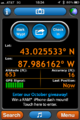
A little while l pulled into the lot. There were no other cars in the lot (a good sign) and the rain was light. My GPS was bouncing a bit but I pulled into the handicapped spot putting me less than four feet from the spot without getting out of my car.
I popped out to take a few pictures of the building including one of myself below the lit sign of the street number.
After that, I was on my way home.
Photos

There I am!
My host for the evening
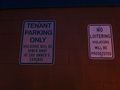
I'm not loitering, I'm geohashing!
GPS
Look! I'm at the spot and in my car!


Achievements
RocketMac earned the Land geohash achievement
|
RocketMac has visited an Easy Geohash
|
RocketMac earned the Last man standing achievement
|