Difference between revisions of "2011-10-21 68 23"
From Geohashing
imported>Isopekka (Created page with "thumb|left {{meetup graticule | lat=68 | lon=23 | date=2011-10-21 }} == Location == About 300 km from my home, in the village of Hetta. ==...") |
imported>Isopekka |
||
| Line 13: | Line 13: | ||
== Location == | == Location == | ||
| − | About | + | About 230 km from my home, in the village of Hetta. |
Revision as of 08:55, 22 October 2011
| Fri 21 Oct 2011 in 68,23: 68.3983438, 23.6980865 geohashing.info google osm bing/os kml crox |
Contents
Location
About 230 km from my home, in the village of Hetta.
Participants
Expedition
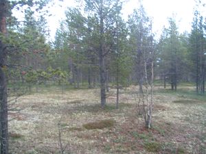
I was returning home from my wildmark cottage and I checked the Hash points for today. Luckily the Hetta-point was in a very easy place: I had to walk only 200 meters from the main road, this time the forest was not so dense, it was almost like a park! Only the last 20 meters were a little bit wet.
- Walking total 400 m
- Expedition took 0.5 h
- Physical effort (1-5): 2
Photos
Achievements
isopekka earned the Land geohash achievement
|
Geohashing Expeditions and Plans on This Day
Expeditions and Plans
| 2011-10-21 | ||
|---|---|---|
| Pakenham, Australia | Felix Dance | Just off a semi-private road behind a farm near Korumburra. |
| Frankfort, Kentucky | kydlt's marionette, Sister Barb | The central Bluegrass |
| Mannheim, Germany | Karl 77, ilpadre | In the woods at the border between Heidelberg's city districts Altstadt and... |
| Northampton, United Kingdom | Sourcerer | A residential road in Kettering, Northamptonshire, UK. |
| Sheffield, United Kingdom | Monty | Moorland, northeast of Ladybower Reservoir, in the Peak District west of Sh... |
| Hetta, Finland | isopekka | About 230 km from my home, in the village of Hetta. |


