Difference between revisions of "2012-03-10 30 -81"
imported>DrCanadianNinja (Created page with "{{meetup graticule | map=<map lat="30" lon="-81" date="2012-03-10" /> | lat=30 | lon=-81 | date=2012-03-10 | graticule_name=Jacksonville, Florida | graticule_link=Jacksonville, F...") |
imported>DrCanadianNinja (→Gallery) |
||
| Line 33: | Line 33: | ||
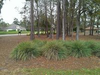
Image:2012-03-10_Geohash.jpg|Just beyond the trees, next to the golf cart path. | Image:2012-03-10_Geohash.jpg|Just beyond the trees, next to the golf cart path. | ||
Image:2012-03-10_StupidGrin.jpg|Obligatory! | Image:2012-03-10_StupidGrin.jpg|Obligatory! | ||
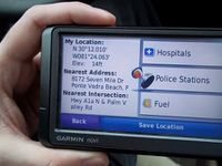
| − | Image:2012-03-10_GPS. | + | Image:2012-03-10_GPS.JPG|On the road from the geohash. Security wasn't happy. |
Image:2012-03-10_Accomplices.jpg|He's allergic to photography. | Image:2012-03-10_Accomplices.jpg|He's allergic to photography. | ||
Image:2012-03-10_TPCSawgrass.jpg|The visitor's pass for the day. | Image:2012-03-10_TPCSawgrass.jpg|The visitor's pass for the day. | ||
Revision as of 18:49, 10 March 2012
| Sat 10 Mar 2012 in Jacksonville, Florida: 30.2001308, -81.3999547 geohashing.info google osm bing/os kml crox |
Expedition
Geohashers
- Dr. Canadian Ninja and two accomplices.
The Plan
I had my eye on geohashing for a few days, but this was the first time I could conceivably get to the hash. Initially, I hadn't planned to, as I had a guest over for the weekend, but he thought it sounded like a fun idea. Checking the map Friday night, the location was inside TPC at Sawgrass, a major pro golf course with restricted entry. For a first time, having to talk my way into a restricted area was not my idea of a good first hash!
Nonetheless, my concerns were vetoed over cries of "ADVENTURE!"
The Adventure
While driving to the golf course, there were a few thoughts. Namely if we should actually play a round of golf; weather, however, was not permitting. We had a bit of a disagreement as to how to talk our way in. My guest thought the best way to do it would be to pretend we were interested in real estate. This was perhaps the sanest of his ideas, as the rest were varying degrees of "case the joint." In the end, his plan was to take a sidestreet, pass through a few empty lots, stick to the trees on the golf course, and come out near the geohash.
Meanwhile, I drove up, spoke to the security guard, and got a visitor's pass. Denying him the ability to trek through the woods, he sulked for the next few minutes.
Rather than go to the clubhouse, like most new visitors were, we took off towards 7 Mile Road, arriving right outside the geohash at 11:50 AM. However, the geohash was right off the tee of a hole I hadn't quite caught the numbering on, and there was a security booth eyeing us up on the approach. To make matters worse, it was starting to rain, and as I've found out on previous trips, my GPS does not like rain. We made it, but security was in a hurry to get us out, so the picture was a bit off. Considering they also followed us out, I don't think they were terribly pleased.
We took a completely different route returning than we had arrived. A Tron achievement was not ours, as 7 Mile Road was a dead end. Security followed us out after we had reached the main road. Still, after a successful geohash, everyone was in high spirits. Except for the GPS, who disliked our planned "let's wing it" route back home that she tried to turn us around a good five or six times, sometimes in rather lengthy ways, before she just gave up. Tangentially, I really wish I had the tracklog enabled, as the maps weren't entirely updated, and made it look like we had just decided roads were for cowards and decided to offroad it to US-1.
Gallery
- Photo Gallery
Achieveables
Dr. Canadian Ninja earned the Land geohash achievement
|
Dr. Canadian Ninja earned the Police Geohash Achievement
|


