Difference between revisions of "2012-04-29 48 11"
imported>The T-Man (Wrote report) |
imported>The T-Man (Added pictures, achievement) |
||
| Line 14: | Line 14: | ||
== Expedition == | == Expedition == | ||
| − | After numerous days of beautiful weather (see [[2012-04-26 48 11]] there were some clouds around this time, creating a humid yet still very hot atmosphere. [[User:Scherzkeks|Scherzkeks]] and [[User:The_T-Man|The_T-Man]] asked [[User:Locationmaster|Locationmaster]] whether he would join in (which he did), got in the car and picked up [[User:DerFlob|DerFlob]] at his place. After a rather long drive (because Scherzkeks had set the navigation system to "shortest route", so we missed the highway) we arrived at Altomünster, a village about 30 km NW of München, which is actually a bit closer to Augsburg than it is to München. | + | After numerous days of beautiful weather (see [[2012-04-26 48 11]]) there were some clouds around this time, creating a humid yet still very hot atmosphere. [[User:Scherzkeks|Scherzkeks]] and [[User:The_T-Man|The_T-Man]] asked [[User:Locationmaster|Locationmaster]] whether he would join in (which he did), got in the car and picked up [[User:DerFlob|DerFlob]] at his place. After a rather long drive (because Scherzkeks had set the navigation system to "shortest route", so we missed the highway) we arrived at Altomünster, a village about 30 km NW of München, which is actually a bit closer to Augsburg than it is to München. |
We started walking out of the village and towards the general direction of the hashpoint. En route, we encountered a hashcat which happened to look a bit like Scherzkeks's cat at home. The_T-Man and Locationmaster patted the cat (for the record: the hashcat was cooperatively purring) and we continued through a fallow field and into the forest. In the forest we had to take a couple of detours with various degrees of wilderness to be passed. At the hashpoint, we constructed our so-far most elaborate camera stand and took a group picture. On our way back, a different route was taken, so that we had walked in a circle-like path about 11 km overall. | We started walking out of the village and towards the general direction of the hashpoint. En route, we encountered a hashcat which happened to look a bit like Scherzkeks's cat at home. The_T-Man and Locationmaster patted the cat (for the record: the hashcat was cooperatively purring) and we continued through a fallow field and into the forest. In the forest we had to take a couple of detours with various degrees of wilderness to be passed. At the hashpoint, we constructed our so-far most elaborate camera stand and took a group picture. On our way back, a different route was taken, so that we had walked in a circle-like path about 11 km overall. | ||
== Photos == | == Photos == | ||
| − | |||
| − | |||
| − | |||
<gallery perrow="5"> | <gallery perrow="5"> | ||
| + | Image:2012-04-29-TMan-01.jpg | Hashcat and [[User:The_T-Man|The_T-Man]] (from left to right) | ||
| + | Image:2012-04-29-TMan-02.jpg | The cat explores a flower bouquet | ||
| + | Image:2012-04-29-TMan-03.jpg | [[User:Locationmaster|Locationmaster]] with cat. Cat still well-disposed towards us. | ||
| + | Image:2012-04-29-TMan-04.jpg | The hashpoint for the following day should have been right next to the houses. | ||
| + | Image:2012-04-29-TMan-05.jpg | View of Altomünster from NW | ||
| + | Image:2012-04-29-TMan-06.jpg | [[User:DerFlob|DerFlob]] points out botanic sights and details. Or explains the route. | ||
| + | Image:2012-04-29-TMan-07.jpg | Some paths we shared with other species. | ||
| + | Image:2012-04-29-TMan-08.jpg | We're there! | ||
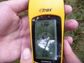
| + | Image:2012-04-29-TMan-09.jpg | The coordinates. | ||
| + | Image:2012-04-29-TMan-10.jpg | "And with this handle you can easily adjust the direction of the camera!" | ||
| + | Image:2012-04-29-TMan-11.jpg | Group shot. (T-Man, Locationmaster, Scherzkeks, DerFlob (left to right)) | ||
| + | Image:2012-04-29-TMan-12.jpg | Bavaria and gardening go together well. | ||
| + | Image:2012-04-29-TMan-13.jpg | Preparations for the Champions League final match. Go Bayern! | ||
</gallery> | </gallery> | ||
== Achievements == | == Achievements == | ||
{{#vardefine:ribbonwidth|800px}} | {{#vardefine:ribbonwidth|800px}} | ||
| − | + | {{Hashcat | latitude = 48 | longitude = 11 | date = 2012-04-29 | name = [[User:Locationmaster|Locationmaster]] and [[User:The_T-Man|The_T-Man]] | image = 2012-04-29-TMan-01.jpg}} | |
[[Category:Expeditions]] | [[Category:Expeditions]] | ||
[[Category:Expeditions with photos]] | [[Category:Expeditions with photos]] | ||
[[Category:Coordinates reached]] | [[Category:Coordinates reached]] | ||
Revision as of 19:40, 30 April 2012
| Sun 29 Apr 2012 in 48,11: 48.4091492, 11.2376230 geohashing.info google osm bing/os kml crox |
Location
In a forest near Altomünster, N of München
Participants
Scherzkeks, DerFlob, The_T-Man and Locationmaster
Plans
Get there by car, go for a walk at the site. Scherzkeks is the designated driver.
Expedition
After numerous days of beautiful weather (see 2012-04-26 48 11) there were some clouds around this time, creating a humid yet still very hot atmosphere. Scherzkeks and The_T-Man asked Locationmaster whether he would join in (which he did), got in the car and picked up DerFlob at his place. After a rather long drive (because Scherzkeks had set the navigation system to "shortest route", so we missed the highway) we arrived at Altomünster, a village about 30 km NW of München, which is actually a bit closer to Augsburg than it is to München.
We started walking out of the village and towards the general direction of the hashpoint. En route, we encountered a hashcat which happened to look a bit like Scherzkeks's cat at home. The_T-Man and Locationmaster patted the cat (for the record: the hashcat was cooperatively purring) and we continued through a fallow field and into the forest. In the forest we had to take a couple of detours with various degrees of wilderness to be passed. At the hashpoint, we constructed our so-far most elaborate camera stand and took a group picture. On our way back, a different route was taken, so that we had walked in a circle-like path about 11 km overall.
Photos
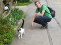
Hashcat and The_T-Man (from left to right)
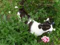
The cat explores a flower bouquet
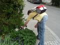
Locationmaster with cat. Cat still well-disposed towards us.
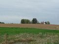
The hashpoint for the following day should have been right next to the houses.
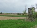
View of Altomünster from NW
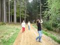
DerFlob points out botanic sights and details. Or explains the route.
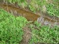
Some paths we shared with other species.
We're there!
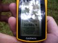
The coordinates.
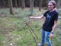
"And with this handle you can easily adjust the direction of the camera!"
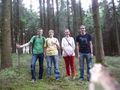
Group shot. (T-Man, Locationmaster, Scherzkeks, DerFlob (left to right))
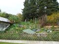
Bavaria and gardening go together well.

Preparations for the Champions League final match. Go Bayern!


Achievements
Locationmaster and The_T-Man earned the Hashcat achievement
|