Difference between revisions of "2012-04-28 52 13"
From Geohashing
imported>Hijackal (Successful puppet master) |
imported>Hijackal (report reported.) |
||
| Line 1: | Line 1: | ||
| − | |||
| − | |||
| − | |||
| − | |||
| − | |||
{{meetup graticule | {{meetup graticule | ||
| lat=52 | | lat=52 | ||
| Line 10: | Line 5: | ||
}} | }} | ||
| − | |||
__NOTOC__ | __NOTOC__ | ||
== Location == | == Location == | ||
| − | + | Conveniently located in the middle of a road in a suburb of Berlin. | |
== Participants == | == Participants == | ||
| − | + | * [[User:Hijackal|Hijackal]]s puppets | |
| − | |||
== Plans == | == Plans == | ||
| − | + | [[User:Hijackal|Hijackal]] notified his puppets of the hash on Friday, along with a short explanation of geohashing. The hash was only about 10 km from the puppets' home, but on third of the earth's circumference from Hijackal's current location. | |
== Expedition == | == Expedition == | ||
| − | + | The puppets were highly successful. EXIF data show they were within an arcsecond of the hash, at meetup time. Unfortunately, noone else showed up to further explain geohashing, so they rewarded themselves with a chilled beverage at a nearby Biergarten before riding back, for a total trip of about 25 km. | |
| − | |||
| − | |||
== Photos == | == Photos == | ||
| Line 33: | Line 24: | ||
--> | --> | ||
<gallery perrow="5"> | <gallery perrow="5"> | ||
| + | File:2012 04 28 52 13 grins.jpg | Happy first-time hashers. | ||
| + | File:2012 04 28 52 13 A.jpg | Hash street, picture taken standing on the hash. | ||
| + | File:2012 04 28 52 13 B.jpg | Hash steet has two sides, like most. | ||
</gallery> | </gallery> | ||
== Achievements == | == Achievements == | ||
{{#vardefine:ribbonwidth|800px}} | {{#vardefine:ribbonwidth|800px}} | ||
| − | + | {{Bicycle geohash | |
| + | | latitude = 52 | ||
| + | | longitude = 13 | ||
| + | | date = 2012-04-28 | ||
| + | | name = Hijackals puppets | ||
| + | | distance = about 25 km | ||
| + | | image = 2012 04 28 52 13 grins.jpg | ||
| + | }} | ||
| + | {{Puppet Master Geohash | ||
| + | | latitude = 52 | ||
| + | | longitude = 13 | ||
| + | | date = 2012-04-28 | ||
| + | <!--| puppet = identity of person manipulated (optional) --> | ||
| + | | name = [[User:Hijackal|Hijackal]] | ||
| + | | image = 2012 04 28 52 13 grins.jpg | ||
| + | }} | ||
| − | + | {{land geohash | |
| − | + | | latitude = 52 | |
| − | + | | longitude = 13 | |
| + | | date = 2012-04-28 | ||
| + | | name = Hijackals puppets | ||
| + | | image = 2012 04 28 52 13 grins.jpg | ||
| + | }} | ||
| − | + | [[Category:Expeditions]] | |
| − | |||
| − | [[Category: | ||
| − | |||
| − | |||
| − | |||
| − | |||
[[Category:Expeditions with photos]] | [[Category:Expeditions with photos]] | ||
| − | + | ||
| − | |||
| − | |||
| − | |||
| − | |||
[[Category:Coordinates reached]] | [[Category:Coordinates reached]] | ||
| − | |||
| − | |||
| − | |||
| − | |||
| − | |||
| − | |||
| − | |||
| − | |||
| − | |||
| − | |||
Revision as of 16:43, 1 May 2012
| Sat 28 Apr 2012 in 52,13: 52.4519755, 13.2477861 geohashing.info google osm bing/os kml crox |
Location
Conveniently located in the middle of a road in a suburb of Berlin.
Participants
- Hijackals puppets
Plans
Hijackal notified his puppets of the hash on Friday, along with a short explanation of geohashing. The hash was only about 10 km from the puppets' home, but on third of the earth's circumference from Hijackal's current location.
Expedition
The puppets were highly successful. EXIF data show they were within an arcsecond of the hash, at meetup time. Unfortunately, noone else showed up to further explain geohashing, so they rewarded themselves with a chilled beverage at a nearby Biergarten before riding back, for a total trip of about 25 km.
Photos

Happy first-time hashers.
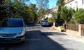
Hash street, picture taken standing on the hash.
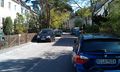
Hash steet has two sides, like most.


Achievements
Hijackals puppets earned the Bicycle geohash achievement
|
Hijackal earned the Puppet Master Geohash achievement
|
Hijackals puppets earned the Land geohash achievement
|