Difference between revisions of "2012-05-21 45 -123"
imported>Jiml m (Add pointer to old nearby hashpoint) |
imported>Jiml (Fill in report info) |
||
| Line 1: | Line 1: | ||
| − | |||
| − | + | ||
| − | -- | + | [[Image:{{{image|2012-05-21 45 -123 Hwy 8.jpg}}}|thumb|left]] |
| + | |||
{{meetup graticule | {{meetup graticule | ||
| lat=45 | | lat=45 | ||
| Line 30: | Line 30: | ||
== Expedition == | == Expedition == | ||
| − | |||
| − | + | Well, I set out for this one, believing that despite the presence of the forest, it would | |
| − | + | be accessible. It was a fairly long trip, but it was a fairly nice day, and it was nicer | |
| + | in the daytime, as opposed to at night, as it was the last time. | ||
| + | |||
| + | I missed the side road the first time, and went past the previous hashpoint, then turned back | ||
| + | to get to the side road. I found it, or rather the other end of the side road, and eventually | ||
| + | found the road that had the hashpoint. And it was only 120 feet from the road to the hashpoint. | ||
| + | |||
| + | Except that the land on the side of the road was almost vertical. So the horizontal | ||
| + | 120 feet was going to be a bit longer. And the vertical slope turned me off on the whole | ||
| + | attempt. | ||
| + | |||
| + | So, Mother Nature won. I turned around and headed to the Portland hashpoint, hoping for | ||
| + | better luck. | ||
| + | |||
| + | |||
== Photos == | == Photos == | ||
| − | + | ||
| − | + | ||
| − | |||
<gallery perrow="5"> | <gallery perrow="5"> | ||
| + | Image:2012-05-21 45 -123 Hwy 8.jpg|The road to the hashpoint | ||
</gallery> | </gallery> | ||
| + | |||
| + | I have some more images, except my camera had gotten flipped over into "Movie" mode | ||
| + | and recorded video instead of still images. I have to figure out how to extract a | ||
| + | single image from the video. | ||
== Achievements == | == Achievements == | ||
| Line 46: | Line 63: | ||
<!-- Add any achievement ribbons you earned below, or remove this section --> | <!-- Add any achievement ribbons you earned below, or remove this section --> | ||
| + | * MNB? | ||
| + | * Geohashing Day | ||
| − | |||
| − | |||
| − | |||
| − | [[Category: | + | [[Category:Expeditions]] |
| − | |||
| − | |||
| − | |||
[[Category:Expeditions with photos]] | [[Category:Expeditions with photos]] | ||
| − | + | [[Category:Coordinates not reached]] | |
| − | |||
| − | |||
| − | |||
| − | |||
| − | [[Category:Coordinates reached]] | ||
| − | |||
| − | + | [[Category:Not reached - Mother Nature]] | |
| − | |||
| − | |||
| − | [[Category:Not reached - Mother Nature]] | ||
| − | |||
| − | |||
| − | |||
| − | |||
Revision as of 00:13, 23 May 2012

| Mon 21 May 2012 in 45,-123: 45.4795496, -123.6426083 geohashing.info google osm bing/os kml crox |
Location
A little bit off a logging road in the Tillamook forest
Participants
Plans
Boy, this one looks tempting. It is a bit off a logging road(?), but the logging road itself it right off Hwy 6. There is just the 37 miles of weaving highway between me and the logging road... :-(
The Tillamook forest does seem to attract potential multihashes: See this one which is 4 miles down the highway.
Expedition
Well, I set out for this one, believing that despite the presence of the forest, it would be accessible. It was a fairly long trip, but it was a fairly nice day, and it was nicer in the daytime, as opposed to at night, as it was the last time.
I missed the side road the first time, and went past the previous hashpoint, then turned back to get to the side road. I found it, or rather the other end of the side road, and eventually found the road that had the hashpoint. And it was only 120 feet from the road to the hashpoint.
Except that the land on the side of the road was almost vertical. So the horizontal 120 feet was going to be a bit longer. And the vertical slope turned me off on the whole attempt.
So, Mother Nature won. I turned around and headed to the Portland hashpoint, hoping for better luck.
Photos
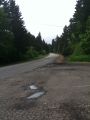
The road to the hashpoint
I have some more images, except my camera had gotten flipped over into "Movie" mode and recorded video instead of still images. I have to figure out how to extract a single image from the video.
Achievements
- MNB?
- Geohashing Day