Difference between revisions of "2012-07-08 47 8"
imported>Calamus |
imported>Calamus (Added photos) |
||
| Line 1: | Line 1: | ||
| − | + | [[Image:{{{image|2012-07-08 47 8 aar.jpg}}}|thumb|left]] | |
| − | |||
| − | [[Image:{{{image| | ||
| − | |||
| − | |||
| − | |||
| − | |||
| − | |||
| − | |||
{{meetup graticule | {{meetup graticule | ||
| lat=47 | | lat=47 | ||
| Line 16: | Line 8: | ||
__NOTOC__ | __NOTOC__ | ||
== Location == | == Location == | ||
| − | An | + | An unclaimed "garden" in Küttigen |
== Participants == | == Participants == | ||
| Line 41: | Line 33: | ||
== Photos == | == Photos == | ||
| − | |||
| − | |||
| − | |||
| − | |||
<gallery perrow="5"> | <gallery perrow="5"> | ||
| + | Image:2012-07-08 47 8 off limits.jpg | "Trail closed" – Pretty convincing | ||
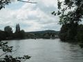
| + | Image:2012-07-08 47 8 aar.jpg | The Aar with Perfectly Accessible Isle | ||
| + | Image:2012-07-08 47 8 fountain of pointlessness.jpg | Those fountains boomed after Geneva built one | ||
| + | Image:2012-07-08 47 8 hashpoint.jpg | The hashpoint | ||
| + | Image:2012-07-08 47 8 isle view.jpg | View from Perfectly Accessible Isle | ||
</gallery> | </gallery> | ||
| Line 56: | Line 49: | ||
[[Category:Expeditions]] | [[Category:Expeditions]] | ||
| − | + | [[Category:Expeditions with photos]] | |
[[Category:Coordinates reached]] | [[Category:Coordinates reached]] | ||
Revision as of 14:35, 9 July 2012

| Sun 8 Jul 2012 in 47,8: 47.4154530, 8.0489693 geohashing.info google osm bing/os kml crox |
Location
An unclaimed "garden" in Küttigen
Participants
Plans
None – this was a spontaneous one.
Expedition
Right after he had spontaneously boarded the train to Aarau, capital of Argovia, after returning from another hash, he wondered whether it had been a good idea. Ever since his childhood, he had had this inexplicable fear of Argovians.
Well, actually it was somewhat explicable. Calamus had almost be run over by Argovians on multiple occasions. Argovians often came to Zurich by car (Zurichois usually didn't drive in the city, but used public transport) and pretended not to know Zurich's traffic rules, such as "don't mistake pedestrian zones for highways". This was a little dangerous for people who weren't very good at climbing lampposts, and so Calamus felt a little queasy going to a town where probably everybody drove like this.
Of course, he couldn't have been any wronger. The Argovians turned out to be a rather nice people, who drove carefully as long as they weren't in Zurich. The town itself was quite appealing as well. The place of the geohash precisely one week ago had been called Au, "flat, wooded meadow by a river", and Aarau meant "flat, wooded meadow by the Aar". The Aar was the river of Aarau, and also of Berne, Olten and what not. It rose from a glacier in the Bernese alps and consumed the Reuss, along which Calamus had wandered to one of his most emotional hashes, and the Limmat, which flows from Lake Zurich and by which Calamus often sat during the summer, as well as many others before emptying into the Rhine.
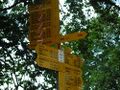
And that was exactly where Calamus stood, at a bridge over the mighty river of Aar. And according to a barred signpost next to it, it was closed due to construction work. Calamus began to walk upriver to the next bridge. When he reached it, he stood there for a moment to gaze upon the quickly flowing water. Upon reaching the closed bridge from the other side, he noticed a sign announcing that construction work wasn't going to start before Tuesday. They had just been swift at changing the signsposts. No matter, the municipality of Küttigen, where the hashpoint was located, was just ahead.
Nothing worth mentioning happened along the well-consideredly laid out trail to Küttigen, which seemed to be designed specificially to provide particulary good views on the Argovian countryside. Küttigen itself appeared rather sleepy – but then again, it was Sunday. Calamus started to look for the hashpoint. It turned out to be between a few houses on a plain, most of which belonged to the garden of one of the houses. However, nobody seemed to want a particular spot in the middle, as it was covered with briars. Luckily for Calamus, the hashpoint turned out to be in a part of the unowned spot that wasn't covered in thorns. He took a picture and returned to Aarau, this time using the perfectly accessible bridge, which led over a lush park isle.
Argovia isn't so bad, he thought as he boarded the train back to Zurich. He would in fact have stayed a little longer if he hadn't had an appointment.
Tracklog
Photos
"Trail closed" – Pretty convincing
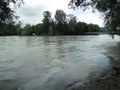
The Aar with Perfectly Accessible Isle
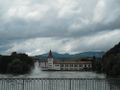
Those fountains boomed after Geneva built one
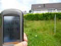
The hashpoint
View from Perfectly Accessible Isle


Achievements
Calamus earned the Land geohash achievement
|
Calamus earned the Public transport geohash achievement
|
Calamus earned the Multihash Achievement
|