Difference between revisions of "2012-07-13 33 -116"
From Geohashing
imported>LucasBrown (→Achievements) |
imported>Eldin m (clean up template, check categories, and add achievement banners.) |
||
| Line 1: | Line 1: | ||
| − | |||
| − | |||
| − | |||
| − | |||
| − | |||
| − | |||
| − | |||
| − | |||
| − | |||
| − | |||
{{meetup graticule | {{meetup graticule | ||
| lat=33 | | lat=33 | ||
| Line 15: | Line 5: | ||
}} | }} | ||
| − | |||
__NOTOC__ | __NOTOC__ | ||
== Location == | == Location == | ||
| Line 24: | Line 13: | ||
== Photos == | == Photos == | ||
| − | |||
| − | |||
| − | |||
<gallery perrow="5"> | <gallery perrow="5"> | ||
| Line 39: | Line 25: | ||
{{#vardefine:ribbonwidth|800px}} | {{#vardefine:ribbonwidth|800px}} | ||
{{Hobbit achievement | latitude = 33 | longitude = -116 | date = 2012-07-13 | name = LucasBrown | pronoun = his}} | {{Hobbit achievement | latitude = 33 | longitude = -116 | date = 2012-07-13 | name = LucasBrown | pronoun = his}} | ||
| + | {{land geohash | latitude = 33 | longitude = -116 | date = 2012-07-13 | name = [[User:LucasBrown|LucasBrown]]}} | ||
| − | |||
| − | |||
| − | |||
| − | |||
[[Category:Expeditions]] | [[Category:Expeditions]] | ||
[[Category:Expeditions with photos]] | [[Category:Expeditions with photos]] | ||
[[Category:Coordinates reached]] | [[Category:Coordinates reached]] | ||
Revision as of 19:52, 23 May 2013
| Fri 13 Jul 2012 in 33,-116: 33.5662695, -116.7369868 geohashing.info google osm bing/os kml crox |
Location
Just north of Ardwell Lane, an unpaved offshoot of an offshoot of State Route 371 in Anza
Participants
LucasBrown reached the hashpoint at 13:00.
Photos
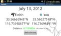
Geohash Droid details page at the hashpoint @33.5663,-116.7370
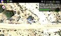
Geohash Droid map at the hashpoint @33.5663,-116.7370
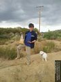
The Hobbit achievement: barefoot, fed, and bearing a (key)ring @33.5663,-116.7370


Achievements
LucasBrown earned the Hobbit Achievement
|
LucasBrown earned the Land geohash achievement
|