Difference between revisions of "2012-07-21 33 -116"
From Geohashing
imported>LucasBrown (→Achievements) |
imported>LucasBrown (→Achievements) |
||
| Line 38: | Line 38: | ||
== Achievements == | == Achievements == | ||
{{#vardefine:ribbonwidth|800px}} | {{#vardefine:ribbonwidth|800px}} | ||
| − | {{Geotrash | latitude = | + | {{Geotrash | latitude = 33 | longitude = -116 | date = 2012-07-21 | name = LucasBrown}} |
[[Category:New report]] | [[Category:New report]] | ||
Revision as of 01:20, 22 July 2012
| Sat 21 Jul 2012 in 33,-116: 33.0420860, -116.4041931 geohashing.info google osm bing/os kml crox |
Location
Just off an unnamed dirt road that splits off of County Road S2 in the Anza-Borrego Desert
Participants
Expedition
Photos
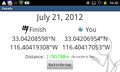
Geohash droid screenshot at the hashpoint
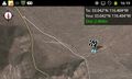
Geohash Droid map at the hashpoint
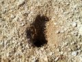
A critter-hole near the hashpoint. In some places the ground was so dense (porous?) with them that the soil caved in underfoot.
Rubber chickens at the hashpoint
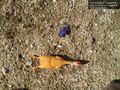
Geotrash Geohash: Refuse found near the hashpoint. Six-inch rubber chicken for scale.
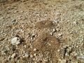
Anthills near the hashpoint
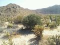
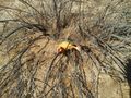
Local flora
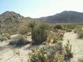
Local flora


Achievements
LucasBrown earned the GeoTrash Geohash Achievement
|