Difference between revisions of "2013-04-17 52 1"
imported>Sourcerer m ([live] Arrived.) |
imported>Sourcerer (→New expedition by Sourcerer) |
||
| Line 1: | Line 1: | ||
| − | |||
| − | |||
| − | |||
| − | |||
| − | |||
| − | |||
| − | |||
| − | |||
| − | |||
| − | |||
{{meetup graticule | {{meetup graticule | ||
| lat=52 | | lat=52 | ||
| Line 15: | Line 5: | ||
}} | }} | ||
| − | |||
| − | |||
== Location == | == Location == | ||
| − | + | In the car park of a company called [http://www.proserv.com/ Proserv] based in Great Yarmouth, Norfolk, UK. | |
== Participants == | == Participants == | ||
| − | |||
[[User:Sourcerer|Sourcerer]] | [[User:Sourcerer|Sourcerer]] | ||
| Line 29: | Line 16: | ||
== Expedition == | == Expedition == | ||
| − | |||
| + | *Gates locked. Re try later. -- [[User:Sourcerer|Sourcerer]] ([[User talk:Sourcerer|talk]]) [http://www.openstreetmap.org/?lat=52.5893372297287&lon=1.7054718732833862&zoom=16&layers=B000FTF @52.5893,1.7055] 07:45, 17 April 2013 (GMT+01:00) | ||
| − | + | At 07:45, it was still too early in the morning and the gates were locked. The hashpoint was only 20 metres away behind a tall fence and the gate. | |
*Arrived. -- [[User:Sourcerer|Sourcerer]] ([[User talk:Sourcerer|talk]]) [http://www.openstreetmap.org/?lat=52.58912265300751&lon=1.7054075002670288&zoom=16&layers=B000FTF @52.5891,1.7054] 16:16, 17 April 2013 (GMT+01:00) | *Arrived. -- [[User:Sourcerer|Sourcerer]] ([[User talk:Sourcerer|talk]]) [http://www.openstreetmap.org/?lat=52.58912265300751&lon=1.7054075002670288&zoom=16&layers=B000FTF @52.5891,1.7054] 16:16, 17 April 2013 (GMT+01:00) | ||
| − | + | ||
| − | + | In the afternoon, the gates were open and it was possible to drive right to the hashpoint where a new photo was taken and a message sent to the Wiki. | |
| + | |||
| + | Although it took two attempts, this was a really easy expedition and I got to see a new part of industrial Britain's oil and gas industries. | ||
== Photos == | == Photos == | ||
| − | < | + | <gallery perrow="4"> |
| − | Image: | + | Image:2013-04-17 52 1 Sourcerer 1.jpg | The Gates were Locked |
| − | -- | + | Image:2013-04-17_52 1 Sourcerer 2.jpg | The Gates were Open |
| − | |||
</gallery> | </gallery> | ||
| − | == | + | == Other geohashing expeditions on the same day == |
| − | |||
| − | |||
| − | |||
| − | |||
| − | |||
| − | |||
| − | |||
| − | + | {{expedition summaries|2013-04-17}} | |
| − | |||
| − | |||
| − | |||
| − | |||
[[Category:Expeditions]] | [[Category:Expeditions]] | ||
| − | |||
[[Category:Expeditions with photos]] | [[Category:Expeditions with photos]] | ||
| − | |||
| − | |||
| − | |||
| − | |||
| − | |||
[[Category:Coordinates reached]] | [[Category:Coordinates reached]] | ||
| − | |||
| − | |||
| − | |||
| − | |||
| − | |||
| − | |||
| − | |||
| − | |||
| − | |||
| − | |||
| − | |||
| − | |||
| − | |||
| − | |||
| − | |||
| − | |||
| − | |||
| − | |||
Revision as of 21:34, 17 April 2013
| Wed 17 Apr 2013 in 52,1: 52.5891163, 1.7053953 geohashing.info google osm bing/os kml crox |
Contents
Location
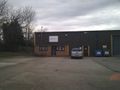
In the car park of a company called Proserv based in Great Yarmouth, Norfolk, UK.
Participants
Plans
Looking at the hashpoints for Wednesday this looks really easy and only a mile or two from my work place. It's in a car park on an industrial estate so "getting lost" will be the excuse for driving there.
Expedition
- Gates locked. Re try later. -- Sourcerer (talk) @52.5893,1.7055 07:45, 17 April 2013 (GMT+01:00)
At 07:45, it was still too early in the morning and the gates were locked. The hashpoint was only 20 metres away behind a tall fence and the gate.
- Arrived. -- Sourcerer (talk) @52.5891,1.7054 16:16, 17 April 2013 (GMT+01:00)
In the afternoon, the gates were open and it was possible to drive right to the hashpoint where a new photo was taken and a message sent to the Wiki.
Although it took two attempts, this was a really easy expedition and I got to see a new part of industrial Britain's oil and gas industries.
Photos

The Gates were Locked
The Gates were Open


Other geohashing expeditions on the same day
Expeditions and Plans
| 2013-04-17 | ||
|---|---|---|
| Boise, Idaho | Eldin , Borneo | On the bank of the Payette River, just west of Emmett. |
| Frankfurt am Main, Germany | Yakamoz | Former US Army barracks on Hannah Arendt Street in Gießen. |
| Norwich, United Kingdom | Sourcerer | In the car park of a company called Proserv based in Great Yarmouth, Norfol... |