Difference between revisions of "2013-05-21 42 -89"
From Geohashing
imported>Swensonj (→Achievements: add) |
imported>Swensonj m (fix up templates) |
||
| Line 40: | Line 40: | ||
| name = SwensonJ | | name = SwensonJ | ||
| image = 2013-05-21_42_-89_Proof.jpg | | image = 2013-05-21_42_-89_Proof.jpg | ||
| + | }} | ||
| + | {{consecutive geohash 2 | ||
| + | | count = 2 | ||
| + | | latitude = 42 | ||
| + | | longitude = -90 | ||
| + | | date = 2013-05-20 | ||
| + | | name = SwensonJ | ||
}} | }} | ||
{{Geohashing Day | {{Geohashing Day | ||
| Line 58: | Line 65: | ||
| speed = 46 mph | | speed = 46 mph | ||
}} | }} | ||
| − | |||
| − | |||
| − | |||
| − | |||
| − | |||
| − | |||
| − | |||
| − | |||
| − | |||
| − | |||
| − | |||
[[Category:Expeditions]] | [[Category:Expeditions]] | ||
| − | |||
[[Category:Expeditions with photos]] | [[Category:Expeditions with photos]] | ||
| − | |||
| − | |||
| − | |||
| − | |||
| − | |||
[[Category:Coordinates reached]] | [[Category:Coordinates reached]] | ||
| − | |||
| − | |||
| − | |||
| − | |||
| − | |||
| − | |||
| − | |||
| − | |||
| − | |||
| − | |||
| − | |||
| − | |||
| − | |||
| − | |||
| − | |||
| − | |||
| − | |||
| − | |||
Revision as of 00:24, 22 May 2013
| Tue 21 May 2013 in 42,-89: 42.6250937, -89.8231275 geohashing.info google osm bing/os kml crox |
Location
Dog Hollow Road between Jordan-Wiota Road and Duncan Hill Road; Jordan Township, Green County, Wisconsin
Participants
Plans
Celebrating Geohashing Day in rural Wisconsin -- sometime between 3:00 and 4:00.
Expedition

Photos
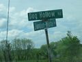
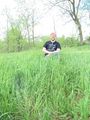
Low-tech location cue: getting close!
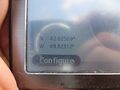
I was there...
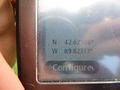
...at least +/- 1 m...
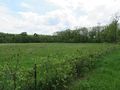
View south from the road
It was a good day for a geohash.
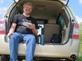
A bit of prior planning allowed me...
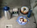
...to celebrate Geohashing Day in style!
On the way home, I drove through fast.


Achievements
SwensonJ earned the Land geohash achievement
|
SwensonJ earned the Consecutive geohash achievement
|
SwensonJ earned the 2013 Geohashing Day achievement
|
SwensonJ earned the Speed racer achievement
|