Difference between revisions of "2013-09-14 47 8"
imported>Calamus (Dunnit.) |
imported>Calamus (Added photos) |
||
| Line 1: | Line 1: | ||
| − | + | [[Image:{{{image|2013-09-14 47 8 cows.jpg}}}|thumb|left]] | |
| − | |||
| − | [[Image:{{{image| | ||
| − | |||
| − | |||
| − | |||
| − | |||
| − | |||
| − | |||
{{meetup graticule | {{meetup graticule | ||
| lat=47 | | lat=47 | ||
| Line 36: | Line 28: | ||
== Photos == | == Photos == | ||
| − | |||
| − | |||
| − | |||
<gallery perrow="5"> | <gallery perrow="5"> | ||
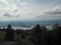
| + | Image:2013-09-14 47 8 topview.jpg | View from the top station | ||
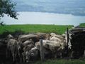
| + | Image:2013-09-14 47 8 cows.jpg | The Cowncil | ||
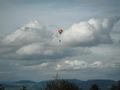
| + | Image:2013-09-14 47 8 glider.jpg | Probably an air hash attempt | ||
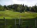
| + | Image:2013-09-14 47 8 up.jpg | Should be up there | ||
| + | Image:2013-09-14 47 8 hash.jpg | The hashpoint | ||
| + | Image:2013-09-14 47 8 hashview.jpg | Zug, seen from the hashpoint | ||
| + | Image:2013-09-14 47 8 crocus.jpg | Ooh, crocus! | ||
| + | Image:2013-09-14 47 8 path of crocus.jpg | Now just don't step on them | ||
</gallery> | </gallery> | ||
| Line 49: | Line 46: | ||
[[Category:Expeditions]] | [[Category:Expeditions]] | ||
| − | |||
[[Category:Expeditions with photos]] | [[Category:Expeditions with photos]] | ||
| − | |||
[[Category:Coordinates reached]] | [[Category:Coordinates reached]] | ||
Revision as of 18:49, 9 January 2014

| Sat 14 Sep 2013 in 47,8: 47.1454788, 8.5319066 geohashing.info google osm bing/os kml crox |
Location
On Zugerberg mountain.
Participants
Plans
Train to Zug leaving Zurich at 2.35pm, bus 11 to Schönegg, then take the funicular to arrive at 3.34. Walk down to Juchenegg to cross the funicular track, then ascend the meadow to reach the point before 4pm.
Expedition
The operator of the funicular going on top of the Zugerberg bore a striking resemblance to French actor Louis de Funès. Calamus admired Lake Zug, which was in plain view of the funicular. Calamus had spent the day making up project proposals for his students, which is more difficult a task than it sounds, so he was happy to get to the mountains for inspiration.
Only once had Calamus been on the Zugerberg ridge before, and it had been on his inaugural expedition. But this time, the hashpoint was considerably lower and, more importantly, had a funicular going right to it. The Schönegg, where the station was located, was a good vantage point and a hit with Zug's tourists, but didn't particularly impress Calamus, to whom the Algorithm had given a much better view two years ago.
Calamus hiked down the only path visible on the maps. On the way, he was overtaken by a biking family, a jockey and some gliders. Soon he reached the lower side of the inclined meadow on which the hashpoint lay. Ascending it was pretty easy, and the hashpoint was reached in time. Upon closer inspection, the upper side of the meadow revealed an overgrown path, leading through a brook and back to the Schönegg, where Calamus took the funicular back down to Zug, his head still devoid of acceptable project outlines.
Tracklog
Photos
View from the top station
The Cowncil
Probably an air hash attempt
Should be up there
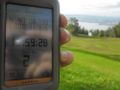
The hashpoint
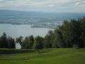
Zug, seen from the hashpoint
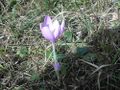
Ooh, crocus!
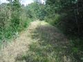
Now just don't step on them


Achievements
Calamus earned the xkcd Decurion achievement
|