Difference between revisions of "2013-09-19 66 25"
From Geohashing
imported>Isopekka (Created page with "thumb|left {{meetup graticule | lat=66 | lon=25 | date=2013-09-19 }} == Location == In Syväsenvaara, in forest. == Par...") |
imported>Isopekka |
||
| Line 34: | Line 34: | ||
| − | Expedition started about at | + | Expedition started about at 4:30 p.m. The Hashpoint situated in the forest. |
==Photos == | ==Photos == | ||
Revision as of 20:09, 19 September 2013
.jpg)
| Thu 19 Sep 2013 in 66,25: 66.5359765, 25.8002534 geohashing.info google osm bing/os kml crox |
Contents
Location
In Syväsenvaara, in forest.
Participants
Expedition
- Driving total 16 km
- Walking total 0.4 km
- Expedition took 0.5 h
- Physical effort (1-5): 1
Expedition started about at 4:30 p.m. The Hashpoint situated in the forest.
Photos
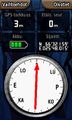
The Proof.
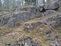
The Hash.
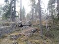
View from the hash.
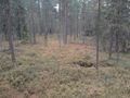
View from the hash.

.jpg)
.jpg)
Achievements
isopekka earned the Land geohash achievement
|
Geohashing Expeditions and Plans on This Day
Expeditions and Plans
| 2013-09-19 | ||
|---|---|---|
| Beersheba, Israel | LinaK | In a field at the Lachish region, close to Highway 6 and The Israel Trail, ... |
| Hannover, Germany | GeorgDerReisende | The hash lies in a small forest south of the interchange between the motorw... |
| Rovaniemi, Finland | isopekka | In Syväsenvaara, in forest. |