Difference between revisions of "2013-09-21 45 -122"
From Geohashing
imported>Michael5000 m (→Photos) |
imported>Jiml m (Result codes look right) |
||
| Line 15: | Line 15: | ||
}} | }} | ||
| − | + | ||
__NOTOC__ | __NOTOC__ | ||
== Location == | == Location == | ||
| Line 26: | Line 26: | ||
== Plans == | == Plans == | ||
| − | + | ||
| + | Plans? | ||
== Expedition == | == Expedition == | ||
| Line 33: | Line 34: | ||
It happens that the field is a youth soccer pitch attached to the church, so it was very easy on a cool autumn morning to saunter out from the parking lot, stand on the hashpoint, drop a temporary marker, and feel that sense of triumph at having once again gone to a random place. | It happens that the field is a youth soccer pitch attached to the church, so it was very easy on a cool autumn morning to saunter out from the parking lot, stand on the hashpoint, drop a temporary marker, and feel that sense of triumph at having once again gone to a random place. | ||
| − | |||
| − | |||
| − | |||
== Photos == | == Photos == | ||
| Line 48: | Line 46: | ||
== Achievements == | == Achievements == | ||
{{#vardefine:ribbonwidth|800px}} | {{#vardefine:ribbonwidth|800px}} | ||
| − | + | ||
| + | |||
| + | * Land Geohash | ||
| + | |||
| + | |||
[[Category:Expeditions]] | [[Category:Expeditions]] | ||
[[Category:Expeditions with photos]] | [[Category:Expeditions with photos]] | ||
[[Category:Coordinates reached]] | [[Category:Coordinates reached]] | ||
| − | |||
| − | |||
| − | |||
| − | |||
| − | |||
| − | |||
| − | |||
| − | |||
| − | |||
| − | |||
| − | |||
| − | |||
| − | |||
| − | |||
| − | |||
| − | |||
| − | |||
| − | |||
Revision as of 13:17, 29 September 2013
| Sat 21 Sep 2013 in 45,-122: 45.3735723, -122.7089212 geohashing.info google osm bing/os kml crox |
Location
Near the Rolling Hills Community Church, west of West Linn off of I-205.
Participants
Plans
Plans?
Expedition
From the aerial images, the big question was whether the hashpoint was in a grassy field accessible to a large suburban church, or in a cultivated field near a large suburban church. Only one way to find out!
It happens that the field is a youth soccer pitch attached to the church, so it was very easy on a cool autumn morning to saunter out from the parking lot, stand on the hashpoint, drop a temporary marker, and feel that sense of triumph at having once again gone to a random place.
Photos

Arriving at the parking lot

It's a BIG church!
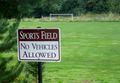
A soccer field with a hashpoint.

Me, at the hashpoint.


Achievements
- Land Geohash