Difference between revisions of "2013-12-25 33 -117"
From Geohashing
imported>LucasBrown (A plank bridge over a creek near the hashpoint [http://www.openstreetmap.org/?lat=33.06890000&lon=-117.08300000&zoom=16&layers=B000FTF @33.0689,-117.0830]) |
imported>LucasBrown |
||
| Line 1: | Line 1: | ||
| + | {{meetup graticule | lat=33 | lon=-117 | date=2013-12-25}} | ||
| − | |||
| − | |||
| − | |||
| − | |||
| − | |||
| − | |||
| − | |||
| − | |||
| − | |||
| − | |||
| − | |||
| − | |||
| − | |||
| − | |||
| − | |||
| − | |||
__NOTOC__ | __NOTOC__ | ||
== Location == | == Location == | ||
| − | + | On the northeast side of Bernardo Mountain, just downhill from the Bernardo Summit Trail | |
== Participants == | == Participants == | ||
| − | + | [[User:LucasBrown|LucasBrown]] and his sister | |
| − | |||
| − | |||
| − | |||
| − | |||
| − | |||
| − | |||
| − | |||
| − | |||
| − | |||
| − | |||
== Photos == | == Photos == | ||
| − | |||
| − | |||
| − | |||
<gallery perrow="5"> | <gallery perrow="5"> | ||
| − | |||
Image:2013-12-25_33_-117_14-37-48-372.jpg | Geohash Droid details page at the hashpoint | Image:2013-12-25_33_-117_14-37-48-372.jpg | Geohash Droid details page at the hashpoint | ||
| − | |||
Image:2013-12-25_33_-117_14-39-47-774.jpg | Map at hashpoint | Image:2013-12-25_33_-117_14-39-47-774.jpg | Map at hashpoint | ||
| − | |||
Image:2013-12-25_33_-117_14-40-37-292.jpg | A plank bridge over a creek near the hashpoint [http://www.openstreetmap.org/?lat=33.06890000&lon=-117.08300000&zoom=16&layers=B000FTF @33.0689,-117.0830] | Image:2013-12-25_33_-117_14-40-37-292.jpg | A plank bridge over a creek near the hashpoint [http://www.openstreetmap.org/?lat=33.06890000&lon=-117.08300000&zoom=16&layers=B000FTF @33.0689,-117.0830] | ||
</gallery> | </gallery> | ||
| − | |||
| − | |||
| − | |||
| − | |||
| − | |||
| − | |||
| − | |||
| − | |||
| − | |||
| − | |||
| − | |||
| − | |||
| − | |||
| − | |||
| − | |||
[[Category:Expeditions]] | [[Category:Expeditions]] | ||
| − | |||
[[Category:Expeditions with photos]] | [[Category:Expeditions with photos]] | ||
| − | |||
| − | |||
| − | |||
| − | |||
| − | |||
[[Category:Coordinates reached]] | [[Category:Coordinates reached]] | ||
| − | |||
| − | |||
| − | |||
| − | |||
| − | |||
| − | |||
| − | |||
| − | |||
| − | |||
| − | |||
| − | |||
| − | |||
| − | |||
| − | |||
| − | |||
| − | |||
| − | |||
| − | |||
Revision as of 22:42, 25 December 2013
| Wed 25 Dec 2013 in 33,-117: 33.0694823, -117.0841345 geohashing.info google osm bing/os kml crox |
Location
On the northeast side of Bernardo Mountain, just downhill from the Bernardo Summit Trail
Participants
LucasBrown and his sister
Photos
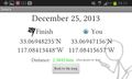
Geohash Droid details page at the hashpoint
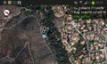
Map at hashpoint
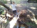
A plank bridge over a creek near the hashpoint @33.0689,-117.0830


